|
San Diego meant at least six landing places for
Golden Age pilots who signed the Davis-Monthan Airfield Register.
Besides Lindbergh Field and the Ryan Flying Field frequented by civilian pilots, there
was Rockwell Field (Army), the San Diego Naval Air Station, and the
aircraft carriers U.S.S. Lexington and the U.S.S. Saratoga populated by Navy aviators.
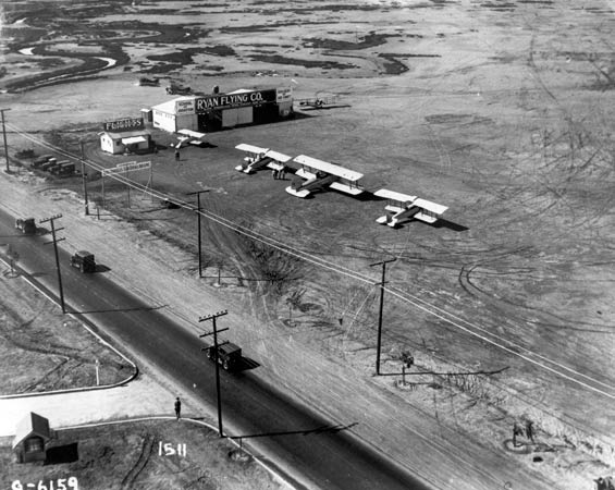
Early on, "Dutch Flats" was in operation when it wasn't flooded. Below, from the San Diego Aerospace Museum (SDAM), is a view of the operations area on a good day. Note "Ryan Flying Service." This photograph can be dated to post-1925 because the largest biplane in the photo is the Douglas "Cloudster" that was purchased by T. Claude Ryan for use on his commercial airline route between Los Angeles and San Diego.
Dutch Flats, Ultimately Ryan Flying Field, After 1925 (Source: SDAM)
 |
Another view of the field, from a slightly different direction, is at the Russell Collection. It shows what the field was like when it was flooded.
---o0o---
Literally hundreds of flights
to the Davis-Monthan Airfield either originated from or terminated
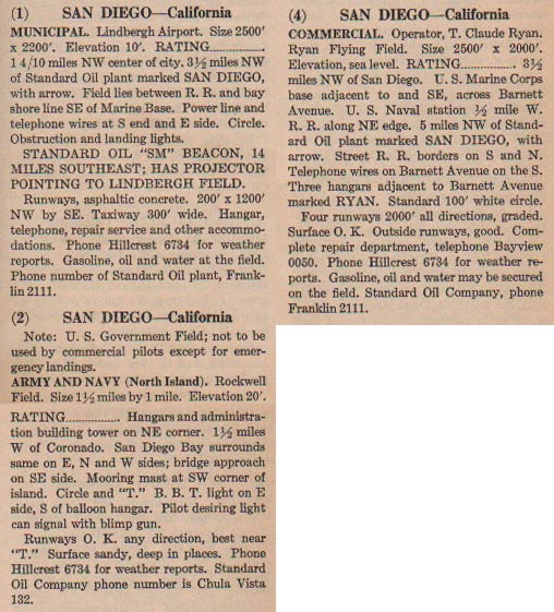
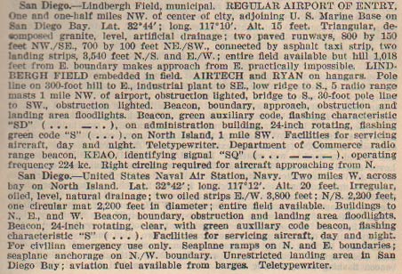
at one of these landing sites in San Diego (right sidebar). Below, from this REFERENCE, page 67, a description of the land-based airfields ca. 1931. N.B. there was also a flying boat facility, but the kind of traffic it saw is mostly irrelevant to the Tucson Register.
San Diego-Area Airfields, Ca. 1931 (Source: Webmaster)
 |
LINDBERGH FIELD
Lindbergh Field, San Diego, CA, Ca. 1933 (Source: Webmaster)
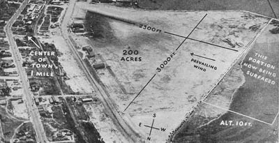 |
Image, left, from this REFERENCE, page 27, shows San Diego, Lindbergh Field, in 1933. Originally
the site of the Ryan Field manufacturing facility, it was named
Lindbergh Field after Lindbergh's
trans-Atlantic flight.
Lindbergh Field in 1933 was located at the foot of Broadway,
one mile northwest of the city center. It was a triangular
surface of decomposed granite. There were no landing or flood
light fees.
Day markings consisted of "LINDBERGH FIELD" painted
on the hangar and "BEACON INN" on the restaurant.
Night lighting was meager, being boundary and flood lights
and two 18" searchlights mounted on the Trust & Savings
Building a mile southeast of the field.
Telephone (dial M-0106) and weather reports were available
on the field. A restaurant was on the field and modern hotels
were five minutes away. Taxi fare to the city was 25 cents,
and buses ran on a fifteen minute schedule.
Fuel, oil and hangars were available, with licensed mechanics
day or night. Operators at the field who provided passenger
service were Pacific Air Transport Boeing Lines, Western Air
Express, Gilpin
Air Lines and Varney Air Lines. Airtech and Ryan School
of Aeronautics, Ltd. provided aerial services, flight training
and aircraft sales.
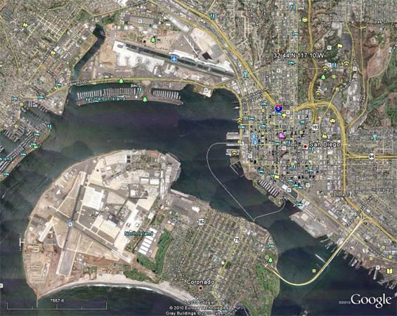
Below, a Google Earth image located by the lat/long values for Lindbergh Field cited in the description below. The specified location is in the upper right quadrant, just east of the contemporary San Diego International Airport. Although there has been a lot of landfilling in the area, I'm not sure if this spot is an accurate geographic representation of the original field.
Lindbergh Field and Naval Air Station, San Diego, CA, Ca. 2010 (Source: Google Earth)
 |
Please direct your browser to the link at this Cosgrove Collection to view a couple of excellent aerial images of Lindbergh and Ryan Fields. The contemporary North Island N.A.S. occupies the bottom half of the image.
ROCKWELL FIELD/NAVAL AIR STATION, NORTH ISLAND
Rockwell Closing, Popular Aviation, February, 1932 (Source: PA)
 |
The Navy's North Island Naval Air Station (N.A.S.) and Rockwell Field (Army) shared the same real estate near Coronado, CA. In a nutshell, Rockwell Field and the N.A.S. operated in proximity on North Island from about 1912-1935. In the mid-30s the Army moved its base of training operations to March Field, Riverside, CA. An aerial view of North Island, ca. 1929, is at Navy pilot William McMullen's page.
The article, at left, is from the February, 1932 issue of Popular Aviation (PA). It announces the closing of Rockwell Field, even though the final removal from operation was in 1935.
Below, from this REFERENCE, page 25, is a description of Lindbergh Field and the N.A.S. ca. 1937. Rockwell Field is not mentioned, since its operations had already moved to March.
Lindbergh Field and Naval Air Station, San Diego, CA, Ca. 1937 (Source: Webmaster)
 |
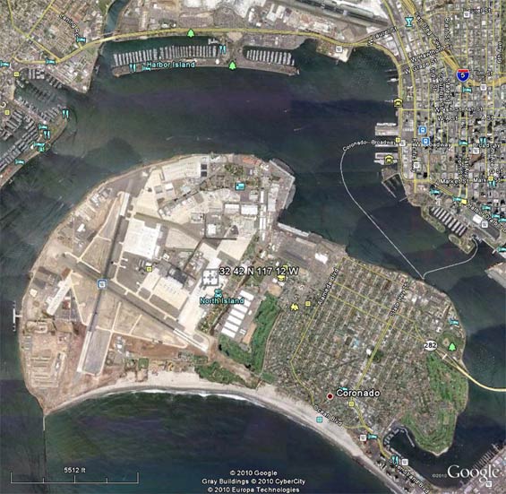
Below, a Google Earth image located (crosshairs) by the lat/long values for the N.A.S. cited in the description above. The specified location is dead in the center of the island.
Naval Air Station, San Diego, CA, 2010 (Source: Google Earth)
 |
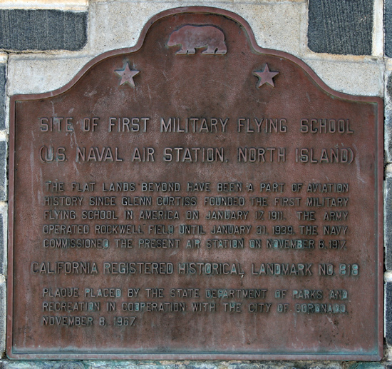
Below, a photograph taken by your Webmaster on May 25, 2009. This historic marker outside the entrance to N.A.S. North Island describes the long history of military aviation, both Army and Navy, that this site represents. Review in the right sidebar the number of military pilots who called San Diego their home or destination.
Rockwell Field & U.S. Naval Air Station, San Diego, CA
(Source: Webmaster)
 |
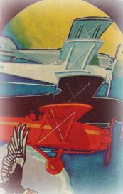
Another view, albeit a cartoon, of San Diego-area airfields is available at the Cooper Collection on dmairfield.org here.
Extra views and information regarding North Island are at this link at the Cosgrove Collection.
---o0o---
UPLOADED: June, 2005 REVISED: 06/10/09, 12/23/10, 06/27/11, 03/13/12, 06/24/14, 12/30/22
|