|
A TOWN ON THE HUDSON RIVER
Poughkeepsie (pronounced poe-KIP-see) is now a city of about
30,000 people on the east bank of the Hudson River, about
midway between New York City and Albany.
Poughkeepsie is entered as a HOMEBASE or DESTINATION only
twice in the register, both times by autogiro pilot John
M. Miller.
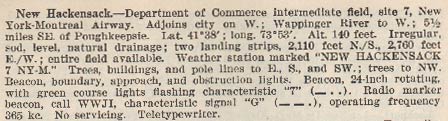
The present-day airport was initially named the New Hackensack Airport. A photograph of the airport allegedly taken May 1, 1936 is at the link. If you magnify this photograph in your browser, you can read "NY-M 7" painted on the roof of the weather station. Compare that with the descriptions, below, from this REFERENCE, These are 1937 descriptions of the New Hackensack and Poughkeepsie location that appear in the same issue. Note the discrepancyies in latitude, runway lengths and altitude.
Bureau of Air Commerce. January 1, 1937. Descriptions of Airports and Landing Fields in the United States (Source: Webmaster)
 |
Bureau of Air Commerce. January 1, 1937. Descriptions of Airports and Landing Fields in the United States (Source: Webmaster)
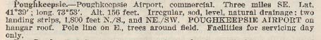 |
A photograph of the field described above is at the link. Note "POUGHKEEPSIE AIRPORT" lettered on the roof of the hangar. IIncidentally, both of these linked photos were taken by Register pilot Victor Dallin.
An artifact of the early Poughkeepsie Municipal Airport is below. It is a handout or brochure shared with us by site visitor M. Crites-Moore. Although undated, it appears probably on the coattails of Charles Lindbergh's successful trans-Atlantic flight in May, 1927. It describes offering a course of study for the aviation sciences, and gives a sense of the excitement surrounding aviation after Lindbergh's flight.
Front Side of the Brochure (Source: Crites-Moore)
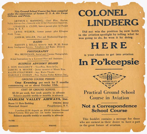 |
Our own John Miller is cited as a ground school resource. Below is the other side.
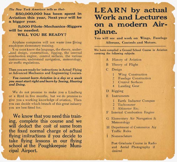
Back Side of the Brochure (Source: Crites-Moore)
 |
Regarding the modern-day Poughkeepsie Municipal Airport, or POU, the image below from Google Earth shows the approximate position of the New Hackensack coordinates given above (light circle) with the northwest corner of the present airport visible in the lower right corner of the image.
Location of "New Hackensack Airport" vis a vis Poughkeepsie Municipal Airport (POU) Source: Google Earth)
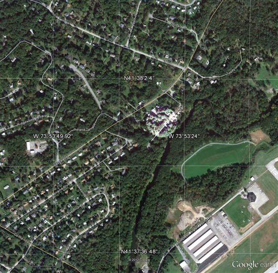 |
I think the juxtaposition of location 41-38N x 73-53W cited for New Hackensack with the present-day POU is conclusive that POU was closely co-located with the old New Hackensack field. The slight difference in location can be explained by measurement error by Golden Age surveyors, or even “drift” over the past 80 years.
Of note in this image, in the lower right corner, you can see airplanes on the ground and the hexagonal terminal building where I met and spoke with John Miller in 2002.
When I spoke with him, I learned that there was an airfield in the area which preceeded the contemporary one. I received the following emails from John regarding
his Golden Age homebase from which he flew his autogiro.
"At the time I was flying the Pitcairn PCA-2 autogiro (NC10781)
the airport was a small one, less than 1500' ground runway,
with an 80 x 100' hangar, built by the city of Poughkeepsie
in 1929. I operated it for a few years 'til 1933. It finally
closed in 1938 and no longer exists. The present airport was
started by the Dept. of Commerce as an emergency field between
NY and ALB, and a few aircraft were based there when the old
airport closed. I never based my autogiro at that new airport.
In WW-II the field was taken over by the Army Air Corps for
training West Point cadets for flying. After the war it was
given to Dutchess County as a public airport with designation
POU. So the old airport is long gone and there are no records
of its activities in existence, since no visitors' log was
kept. John M. Miller."
I asked John to clarify the exact location of the old field
and he sent me this:
"It it was in the NE corner between Vassar Rd. and Spackenkill
Rd., now covered by residences, a gas station on the corner
and a bank where the hangar stood. I have a photo taken from
the air. There were two dirt runways, SW and W. with high
trees in the NE corner, to come over on landing approach.
No takeoffs to the NE over those trees, just SW and W takeoffs.
Very fine for the old biplanes, but NG for today''s planes.
I made about 3 Zero/Zero landings in dense ground fog in the
autogiro, locating the NE corner of the field by the headlights
of the cars and the tops of the trees. I just left a little
power on as I came over the trees and let the autogiro make
its own landing in the dense fog, headed SW. It was a wonderful
aircraft. John."
Unfortunately, he was not able to supply his photograph. Below, an image from Google Earth of the intersection, bank and gas station.
Location of Old Poughkeepsie Airfield, 2008
(Source: Google Earth)
 |
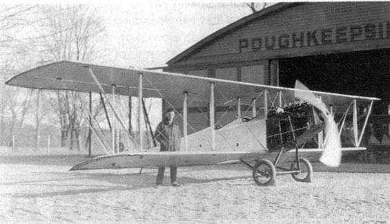
Two photos of Miller's opeartion at the old Red Oaks Mills airfield are below. First one shows John standing beside the Curtiss he refurbished. Please refer to Miller's bio page for details of his acquisition of this airplane.
Old Poughkeepsie Airfield, Ca. 1929 (Source: Robbins)
 |
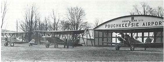
Below, the flight line at the airfield with a trio of New Standard D-25 aircraft. Miller may be leaning against the wing of the center craft. Note the new coat of paint and the name "Giroflyers, Ltd." lettered on the hangar. That was the name of Miller's company.
Old Poughkeepsie Airfield, Ca. 1929 (Source: Robbins)
 |
The following article appeared in the Poughkeepsie Journal of November 2, 2011. The illustration mirrors the Google Earth image above.
DATELINE
Red Oaks Mill
Red Oaks Mill Airport thrived in the 1930s

Written by Anthony P. Musso
For the Poughkeepsie Journal
"While the Red Oaks Mill section of Poughkeepsie now boasts commercial businesses and single-family home developments, in the 1930s it served as home to a busy airport.
The airport, based at Route 376 and Spackenkill and Vassar roads,
featured two dirt runways and an 80-by-100-foot hangar in the vicinity of today's Pine Tree Drive.
The airport was established in 1927 amid nationwide excitement that was
generated from that year's New York-to-Paris nonstop solo flight by Charles Lindbergh.
"Located on property owned by Fred Cleveland, Poughkeepsie Mayor John
Kelsey Sague had the city lease the land and start the airport in 1927,"
said Town of Poughkeepsie Historian Jean Murphy.
"Sague's son-in-law, John M. Miller, a barnstorming pilot and a 1927
mechanical engineer graduate of Pratt Institute, ran the Red Oaks Mill Airport from 1931 to 1933," Murphy explained.
Miller was born in 1905. He became a pilot after watching aviation pioneer Glenn Curtiss land an airplane into a field across from his home in Poughkeepsie.
Miller, a legend in his own right, was a barnstorming aviator who set cross-country records, participated at airshows and had a career as an air transport pilot.
He witnessed Lindbergh's departure from Roosevelt Field on Long Island for his groundbreaking 1927 flight.
Prohibition provided work at the local airport. "Most of the lucrative business at the Red Oaks Mill Airport was the repair of bootleggers' planes, which experienced much wear in frequent
trips across the Canadian border," said Poughkeepsie's Albert Gerney.
Miller gave up oversight of the airport at the end of Prohibition.
The reason? A significant falloff in income generated from repairs made there.
Because the Red Oaks Mill Airport was too small to handle the increasing size of airplanes, the U.S. Commerce Department opened another airport in 1932 just south in New Hackensack to serve as an emergency landing field halfway between New York City and Albany.
"The noise at the Red Oaks Mill Airport became burdensome to neighbors, especially Mr. Howell, who lived next door to today's Mobil gas station at the busy intersection," Gerney said.
"Howell bought the property from Cleveland, shut the airport down in 1938 and sold off parcels to build houses," Gerney added.
The New Hackensack Airport flourished into today's Dutchess County Airport [today's POU].
During Red Oaks Mill Airport's heyday, Cole Palen, a student at a one-room schoolhouse across from the hangar (in a building now occupied by the Fitzgerald Tile Company) was inspired to get involved in aviation.
Palen took his first flight from the airport in 1935 at 10 years old.
Captivated by the experience, Palen made aviation a lifelong pursuit and in 1959 founded the Old Rhinebeck Aerodrome in Red Hook. The site continues to stage air shows during summer months.
The Red Oaks Mill Airport hangar was subsequently used as a post office and blacksmith shop.
In the late 1960s, Hilber Heuer's Hardware Store operated in the structure. A fire destroyed the structure, thereby eliminating the last remnant of aviation history in the community."
|
---o0o---
THIS PAGE UPLOADED: 10/16/08 REVISED: 10/18/08, 11/28/11
|

