| John
Miller, when he landed his autogiro NC10781
here in May of '31, said of the Lordsburg airport, "Lordsburg
was nothing but a gas pit in 1931. I got 'goathead' seeds
in my tires at Lordsburg." |
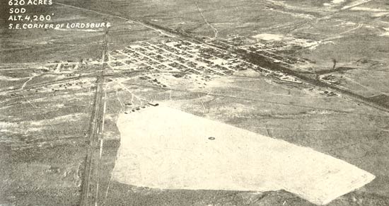
At that time, Lordsburg Municipal Airport adjoined
the southeast corner of the city of Lordsburg, NM. Then, and
as in the photo below taken a couple of years later in 1933,
its sod and gravel surface sat at about 4,280 feet altitude
at approximately N 32° 20.0' W108° 41.5'. In 1933,
LORDSBURG was written on the roof of a warehouse on the south
side of the southern Pacific Railroad. The right-most building
in this photo might be it. The field had obstruction lights,
and the entire area was available for landing in any direction.
A telephone was available, number 113, as well as a one-way,
U.S. Army radio station, WYZ, transmitting on 200 kcs.
Hotels and restaurants were available in town,
with taxi service that had a "slight charge" to
town. Fuel and oil were available, as well as mechanics on-call.
There were no landing fees. Storage cost $1.00 per day, with
weekly and monthly storage "pro-rated".
The view in the 1933 photo below is toward the
northwest, with the railroad running east-west off the image,
center right. Read on and analyze the rest of the images as
a test of your orientation and situational awareness skills!
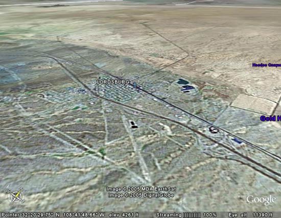
This contemporary image below, from Google Earth, shows the
Lordsburg Municipal Airport juxtaposed to the southeastern
edge of town, as above. I've oriented/tilted the Google Earth
map so that the railroad (touching the "G" in Lordsburg)
is oriented about the same way it is in the 1933 image above.
The airport runways and buildings are at bottom center of
the image.
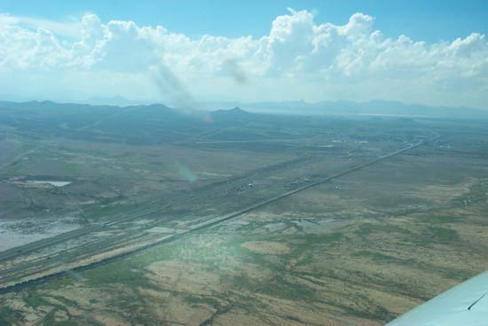
Below is a view to the southwest out the left front of my
airplane (see bugs smashed on window). It was taken in September,
2002 as I approached Lordsburg airport following the railroad
tracks from the east. I am north of the tracks. The railroad
curves away in the distance, with Interstate 10 paralleling
it . The airport and runways 01-19 lie faintly at center.
Note dry lakes in the distant west.
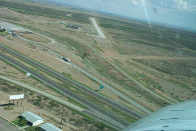
Today, even after 80 years, Lordsburg still
is a small airport, as shown in this photo, left, taken as
I turned final for runway 12 (the dirt runway 01-19 is just
visible crossing the asphalt just beyond the airport buildings).
Construction of Interstate 10, in the foreground,
caused the runway to be moved to its current location a few
hundred yards toward the top of this photo. The original runway
where John Miller,
Charles Lindbergh
and many others landed during the Golden Age was about where
the frontage road and I10 exit ramp are today (visible just
under the nose of my airplane). Compare the 1933 image with
the 2006 Google Earth map and you can see how the interstate
highway construction penetrated the area of the old airport
and forced its displacement toward the southeast.
The railroad tracks, which parallel I10 just
out of view at the bottom of the picture above, are in the
same location as during the Golden Age. Well before the interstate
highway system was conceived, these tracks were used for Golden
Age "flight guidance" between Tucson, Lordsburg
and El Paso.
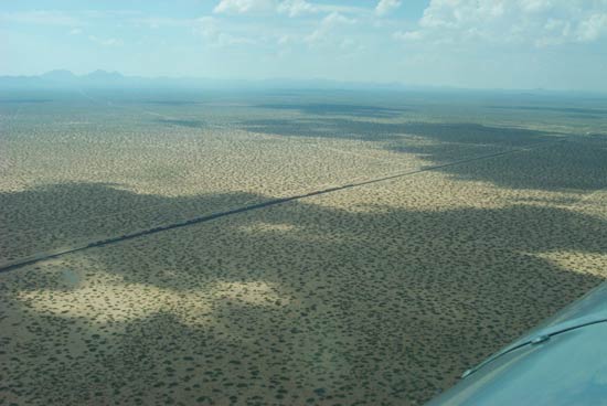
To acquire insight into what our pilots on this
Web site experienced as "flight guidance", I flew
from El Paso to Lordsburg low and slow at 500 feet, following
the same railroad, racing with the westbound freight trains
(image below). For this flight, I had radar coverage and the
full cooperation of Albuquerque Center who appreciated -- they thought it
was a great idea -- my flight in celebration of our predecessors. Let me take this opportunity to give public
thanks to our Air Traffic Controllers.
On this bumpy afternoon, above the mesquite
and cloud shadows, and somewhere between El Paso and the dry
lakes west of Lordsburg, I found out how really hooked I am
on this project of mine. This is hard to admit, but as I flew
along with tears in my eyes, I called out at the top of my
lungs, over the engine noise, the names of some of the pilots
who had traveled this very same route so long ago. And they
answered me.
---o0o---
UPLOADED: 01/15/06 REVISED:
|