|
 |
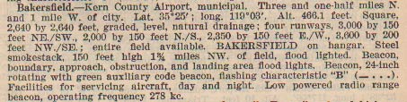
||||
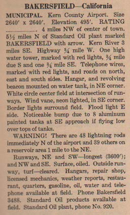
BAKERSFIELD, CA, KERN COUNTY AIRPORT |
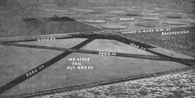
||||
|
| YOU CAN HELP | ||||||
|
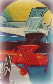
I'm looking for information and photographs of this airplane to include on this page. If you have some you'd like to share, please click this FORM to contact me. ---o0o--- Who Went to Bakersfield? Three pilots who landed at the Davis-Monthan Airfield called Bakersfield their Homebase. |
||||||
|
No pilots arrived at Davis-Monthan Airfield from Bakersfield, and none listed it as their final Destination. ---o0o--- Art Goebel's Own Story by Art Goebel (edited by G.W. Hyatt) is written in language that expands for us his life as a Golden Age aviation entrepreneur, who used his aviation exploits to build a business around his passion. Available as a free download at the link. ---o0o--- Winners' Viewpoints: The Great 1927 Trans-Pacific Dole Race is available at the link. What was it like to fly from Oakland to Honolulu in a single-engine plane during August 1927? Was the 25,000 dollar prize worth it? Did the resulting fame balance the risk? For the first time ever, this book presents the pilot and navigator's stories written by them within days of their record-setting adventure. Pilot Art Goebel and navigator William V. Davis, Jr. take us with them on the Woolaroc, their orange and blue Travel Air monoplane (NX869) as they enter the hazardous world of Golden Age trans-oceanic air racing. ---o0o--- Clover Field: The First Century of Aviation in the Golden State. With the 100th anniversary in 2017 of the use of Clover Field as a place to land aircraft in Santa Monica, this book celebrates that use by exploring some of the people and aircraft that made the airport great. ---o0o--- |
Contact Us | Credits | Copyright © 2008 Delta Mike Airfield, Inc. This website is best enjoyed in a 1024 x 768 screen resolution. Web design by The Web Professional, Inc |
|