|
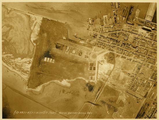
Below, an image of the airport from directly overhead taken May 7, 1931, at high noon from 7,200 feet. This military photograph is shared with us by Tim Kalina. Mr. Kalina says about this image, "The dark hanger at the very left top is marked BOSTON M. The hanger to its right has what may be the Curtiss-Wright logo painted on top. The next hanger down the line reads CURTISS. The two dark hangers at the center right, with the row of four airplanes parked in front, are U.S. Army hangers (as you can read on the roof of one of them). A nice thing about these USAAC aerial photos is that they give not only the exact date but the time of day as well. And note that north is to the bottom of this photo."
In the original photo, at least 26 airplanes are visible on the ground near the hangars, with one operating on the landing surface. There is also a seaplane moored at the short ramp at the top of the airport property, with what looks like a small cluster of automobiles and perhaps a truck standing by.
Boston Municipal Airport, 1931
 |
In 1933, the airfield was a 100-acre, triangular, level cinder surface, six feet above sea level. Below, an oblique aerial image of the airport ( 1933 reference, left sidebar). Note the biplane (a Stearman C3B?). The compass orientation is about the same as the photo above, with north being toward the bottom of the image.
Restaurants were available at the field, as well as in the city of Boston. Cab cost 50-cents to get to town. Pilots could get fuel, oil and repair services. There were no landing fees, but flood lighting cost $10/hour "For extraordinary use".
Boston Municipal Airport, 1933
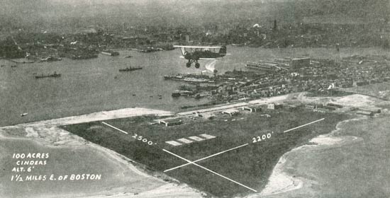 |
Operators at the airport in 1933 included American Airways, Ames Skyways, Inc., a school and charter service, as well as aerial photography (they took the image above), Curtiss-Wright Air Terminals (school, charter trips, aerial photography), Inter-City Airlines, the National Guard 191st Observation Squadron, the U.S. Army Air Corps, New England Aircraft School and the New England Giro Corporation. There were seaplane landing and support facilities at a ramp on the southwest end of the field.
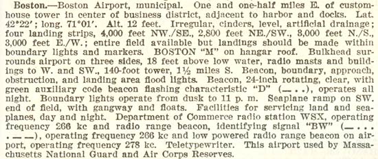
In 1937, the airfield is described by the Department of Commerce (1937 reference, left sidebar) as follows. Airport lighting, radio services and hangar signage were the same as for the 1933 facility description.
Boston Municipal Airport, 1937
 |
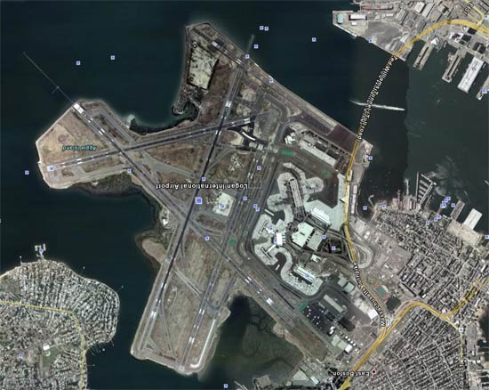
Below, Boston Logan International Airport as it appears today via Google Earth. I turned the image upside down so that north is to the bottom, as in the other two photos above. It appears that the area of the original landing field is now covered with terminal/gate structures. The contemporary runways are on landfilled areas to the left.
Boston Logan International Airport, 2008
 |
---o0o---
UPLOADED: 12/05/08 REVISED: 12/19/22
|