Douglas International Airport, Ca. 1931 (Source: Webmaster)
 |
Douglas, AZ is cited in the Register 160 times. Ten landings logged in the Register cited Douglas as their home base. Seventy-two flights arrived at Tucson from Douglas, and 78 flights identified Dougas as their final destination. Its proximity to the Mexican border made it a popular weekend "port of entry" into Mexico for thirsty pilots during Prohibition.
There are presently two airports in the Douglas, AZ area. The Bisbee-Douglas International Airport is located a few miles northwest of the city, and the Douglas Municipal Airport is to the east and immediately adjacent to the contemporary city of Douglas.
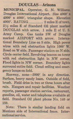
At left, from this REFERENCE, page 26, is a description of the Douglas Municipal Airport (called the Douglas International Airport in the text). The airfield is cited as being two miles east of town. This was true in 1931, but today the city has sprawled eastward so that it now shares its eastern boundary with the airport. The southern boundary of Douglas Municipal is coincident with the U.S.-Mexico border with the town of Agua Prieta to the south.
Note that it had no designated runways: the entire airfield area was open for landing. I believe this facility is at the approximate geolocation of the airfield frequented by Tucson Register signers. There does not appear to be anything remaining of the, "... similar landing field on Mexican side of International fence."
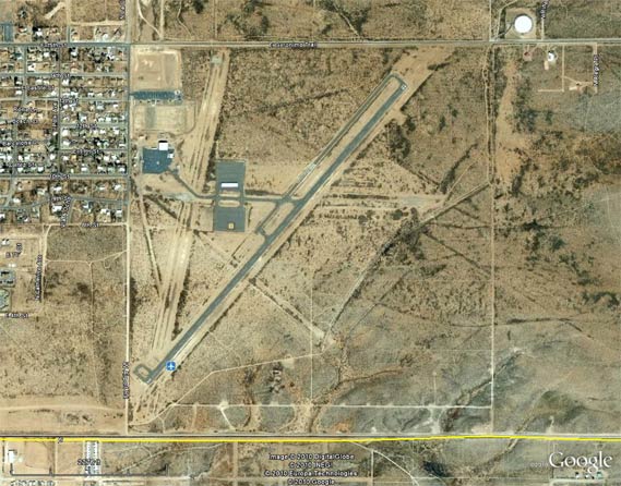
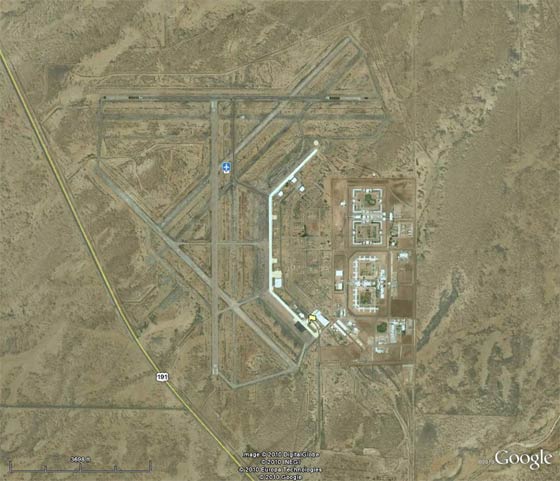
Below is a Google Earth view of the contemporary Douglas International/Municipal Airport. The city of Douglas encroaches at the west. The mentioned highway (Geronimo Trail) runs across the northern boundary. The yellow line is the U.S.-Mexico border. The scars of old runways are visible on the soil, but it is not clear when they were active (possibly during WWII when the airfield was a training facility for U.S. Army airmen, but see below).
Douglas International/Municipal Airport, 2010 (Source: Google Earth)
 |
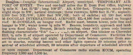
Below, from this REFERENCE, page 5, a description of Douglas International/Municipal from 1937. The description of the runways coincides with the "shadows" of old runways visible in the photo above. There are three; one EW, one NW-SE and one NE-SW. Perhaps these are the ones that were active later during the 30s when Register pilots visited Douglas. Note the addition of the Department of Commerce radio station KCCM. Two period photos from the 1940s are at the link.
Douglas International Airport, Ca. 1937 (Source: Webmaster)
 |
The second airfield is the Bisbee-Douglas International Airport, which is located some 8 miles northwest of the city. Below, from Google Earth, is a 2010 view of the area. This airfield has its origins in the 1940s as a training base for U.S. Army aviators.
Bisbee-Douglas International Airport, 2010 (Source: Google Earth)
 |
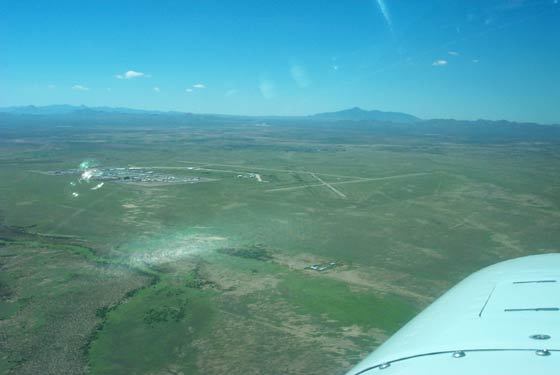
Below, your Webmaster visited this airfield on September 13, 2002. Below is the approach from the northeast.
Bisbee-Douglas International Airport, 2002 (Source: Webmaster)
 |
---o0o---
THIS PAGE UPLOADED: 12/16/10 REVISED: 11/29/11
|