Marysville, CA, Ca. 1931 (Source: Webmaster)
 |
There are two Marysvilles cited in the Register by pilots. Marysville, CA and Marysville, MI. Neither is easy to document.
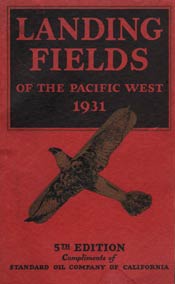
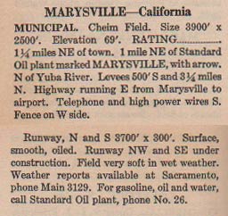
Marysville, CA is located in Yuba County in northern California. The local airport was called Cheim Field. At right, from this REFERENCE, page 48, a description of the Marysville airport in 1931. One pilot, R.H. Dickenson, identified it as his final destination.
There is little I could find online about this airfield. Contemporary Marysville has the Yuba County Airport, but this field was established in December, 1943. I came dry on this one. If you can HELP, please do so at the link.
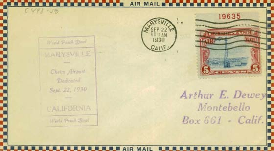
That said, there was one clue to the origin of Cheim field. Below is a first day cover for an air mail stamp that commemorated the establishment of the field on September 22, 1930. This envelope was found at the link. This cover is worth about $3.00 to collectors today.
First Day Cover, September 22, 1930 (Source: Web)
 |
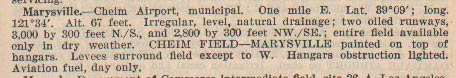
Below, from this REFERENCE, page 21, a description of the Marysville airport in 1937. The NW-SE runway that was under construction in 1931 is operational in 1937.
Marysville, CA, Ca. 1937 (Source: Webmaster)
 |
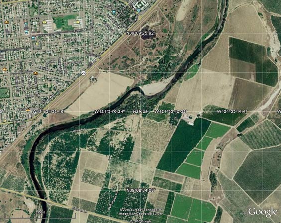
Below, from Google Earth, an arial view at the latitude and longitude coordinates given in the 1937 description. According to the 1937 fix, he old Cheim Field would be about dead center in this view, which is about a mile or so east of Marysville, as described.
Latitude & Longitude of Cheim Field, 1937 (Source: Google Earth)
 |
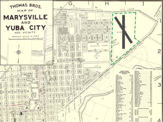
However, site visitor Eric Radecki provides the following chart from the late 1930s or possibly the prewar 1940s (Mr. Radecki is not sure as there is no date). He has overlaid the property boundary and approximate runway geometries on the chart.
The difference between the coordinates given in 1937 and the location of the airfield property today is approximately a half mile. The difference can be explained in a number of ways, including measurement error and land movement in this geologically active area. The airport area today is a neighborhood full of houses located north of the river and north of the levee that cuts diagonally in the upper left quadrant of the Google Earth image. The farmland is in a flood plain and is frequently under water. Thanks to Mr. Radecki for sharing this chart with us.
Marysville, CA , Airport Location, Ca. 1939-40 (Source: Radecki)
 |
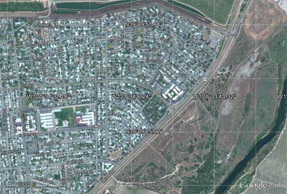
Below, an updated Google Earth image of the triangular property that was the Marysville airfield. Note the lat/long coordinates.
Marysville, CA , Airport Location, 2011 (Source: Google Earth)
 |
The contemporary Yuba County Airport lies about a mile south-southeast of city center.
---o0o---
THIS PAGE UPLOADED: 12/19/10 REVISED: 12/23/11
|