|
Among the airfields cited in the Register, Phoenix is one of the most numerous among the 3,000+ landings recorded. Eighty-four landings recorded in the Register identify Phoenix as their home base. An impressive 243 arrived at Tucson from Phoenix, and 211 were headed toward Phoenix as their final destination.
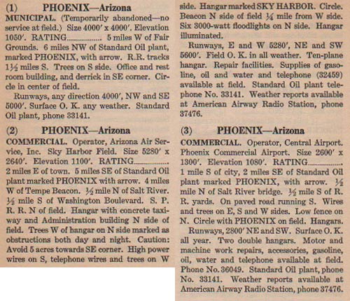
Below, from this REFERENCE, page 58, is a description of the three airfields that served the Phoenix area. Except for pilot Robert W. Henderson, whose log book clearly identifies Municipal as his base of operations, it's impossible to know which of the airfields were used by Register pilots who cited Phoenix. The most likely was #2, Sky Harbor Field.
Phoenix Airfields, Ca. 1931 (Source: Webmaster)
 |
Phoenix Municipal (#1) lost favor as an airfield ca. 1929. And little wonder. It was located far west of the center of Phoenix. It was sometimes called Christy Field. Sky Harbor (#2) was more centrally located and it was dedicated November 16, 1928. Business slowly siphoned away from the Municipal field and it became "temporarily abandoned" sometime between 1929 and 1931. As far as I know, it never reopened. Register pilot J. Parker VanZandt's Scenic Airways operated out of Sky Harbor. Some of the airfields in the Phoenix area during the Golden Age are addressed at the link (as of 12/25/22 this link is blocked by a browser guard).
Central Airport (#3) was located about a mile west of Sky Harbor. According to the link above, the address was 1601 S. Central Avenue, about on the corner of Cocopah and Mohave. Google Earth shows no trace of an airfield there today, rather it is the site of the local Salvation Army and a stone supplier, among other businesses.
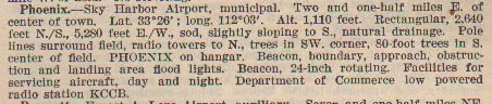
Below, from this REFERENCE, page 7, a description of Phoenix Sky Harbor Airport, ca. 1937.
Phoenix Sky Harbor Airport, Ca. 1937 (Source: Webmaster)
 |
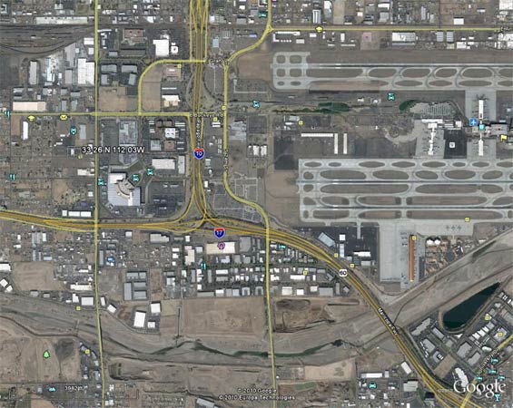
Below, from Google Earth, the location (according to the lat/long values in the image above) of the original Sky Harbor Airport is identified as a couple of hundred yards west of the current Phoenix Sky Harbor International Airport. The old location, as described in 1931, was, "... 1/2 mile N of Salt River. 1/2 mile S of Washington Boulevard." The Salt River is visible at the bottom of the photo below; Washington is just off the top of the image. The Southern Pacific Railroad ("S.P.R.R.") siding is visible in the very top left corner.
The coordinates listed in the description above are shown near the left side of the photo; the western ends of the current International airport runways are at right. The location of the old airfield is near the properties of the rental car businesses affiliated with the airport, and of the U.S. Post Office on E. Buckeye Rd. Given that the lat/long were measured in the late 1930s, it is probably fair to say that the old and new Sky Harbor airports are co-located.
Phoenix Sky Harbor International Airport, Ca. 2010 (Source: Google Earth)
 |
---o0o---
THIS PAGE UPLOADED: 12/20/10 REVISED: 10/18/11, 12/25/22
|