San Francisco Army & Municipal Airports, Ca. 1931 (Source: Webmaster)
 |
Both civil and military Register pilots had two primary landing fields at San Francisco during the Golden Age of Flight: the San Francisco Municipal Airport and Crissy Field, respectively. A third facility, Hamilton Field in Marin County, began construction in 1932.
While not serving the hundreds of landings by Register pilots on the west coast, like San Diego or Los Angeles, San Francisco received its share, as cited in the right sidebar.
SAN FRANCISCO MUNICIPAL AIRPORT
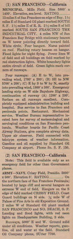
At right, from this REFERENCE, page 68, a description of the two facilities. The Municipal Airport had a U.S. Weather Bureau representative on the field, a real feature for flyers in the area due to the rapidly changing weather, and characteristic fog and low visibilities. A telotype [sic] telephone were also available.
In addition to the description at right, a 1933 description, from this REFERENCE, page 28, says, "Favorably situated beside
the Bayshore Highway, San Francisco Airport is but twenty-two
minutes from the heart of San Francisco. Beside private automobile transportation, with large parking space, all transport planes
are met by taxicabs stationed at the field. Pacific Greyhound
Lines maintain a twenty minute schedule between the airport
and the city."
The San Francisco Municipal Airport was located twelve miles
south of the main postoffice in San Francisco, bounded on
the east by San Francisco Bay and on the west by the four-lane
(see photo) Bayshore Highway.
Day markings consisted of "SAN FRANCISCO AIRPORT"
painted on a hangar (chrome yellow letters on a black background),
a wind cone and an arrow pointing north painted on hangar
No. 1, and a wind indicator at the east side of the field.
Night lighting consisted of floodlights, boundary lights,
an illuminated wind cone and wind tee, buildings floodlighted
and outlined in red, and an alternate green and white revolving
beacon.
In 1933, telephone was available at the field, as was teletype and
weather reports. As a new addition, radio station KGYO, 278 kilocycles, operated
at the field.
Accommodations included a restaurant and rest rooms on the
field, and hotels and restaurants in the city. Taxi, bus,
train and street car transported air passengers to town.
Fuel, oil and hangars were available, as were licensed mechanics
day and night. There were no landing or flood light charges.
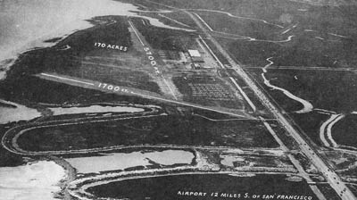
Below, from the 1933 reference, an aerial photograph of the San Francisco Municipal Airport. San Francisco Bay is at the left edge of the photograph, indicating that this aerial view was taken from the north. Compare this image with the one of the contemporary International Airport, below.
San Francisco Municipal Airport, Ca. 1933 (Source: Webmaster)
 |
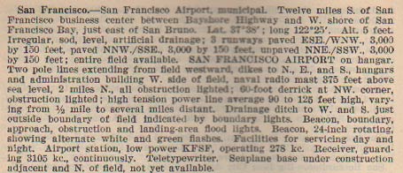
Below, from this REFERENCE, page 26, a description of the Municipal Airport ca. 1937.
San Francisco Municipal Airport, Ca. 1937 (Source: Webmaster)
 |
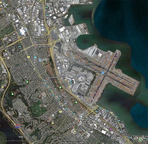
Below, a Google Earth view of the contemporary San Francisco International Airport. North at top. The location specified by the lat/long coordinates cited in the image above is shown in the upper left quadrant of the image. The new airport is built on a landfilled extension into the San Francisco Bay. This accounts for the some of the location discrepancy.
San Francisco International Airport, Ca. 2010 (Source: Google Earth)
 |
CRISSY FIELD
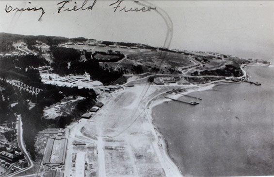
Crissy Field was located on the grounds of the Presidio of San Francisco. The airfield consisted of a single E-W paved runway (approximately 2,500 ft. long). It was built in 1921 under the direction of Register pilot, and then major, H.H. "Hap" Arnold. Not only the establishment, but the reputation of Crissy Field was enhanced by Register pilots. The first Army non-stop transcontinental flight piloted by John Macready and Oakley Kelly visited Crissy at the end of their flight in 1924. The Round the World Flight of Douglas world cruisers landed there with Lowell Smith, Les Arnold, Erik Nelson, and Alva Harvey among the group. And in 1927, Lester Maitland and Albert Hegenberger departed Crissy Field in their Fokker C-2, 26-202, "Bird of Paradise," to make the first non-stop flight from the U.S. west coast to Hawaii. Below, courtesy of the San Diego Aerospace Museum Flickr Stream (SDAM), is an undated aerial photograph of Chrissy Field. The view is west.
Early Aerial View of Chrissy Field (Source: SDAM)
 |
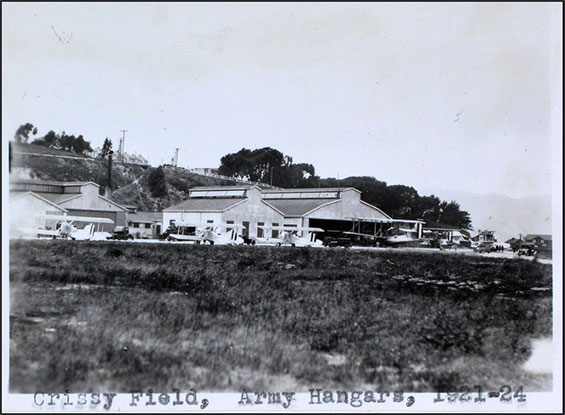
Another early SDAM photograph, below, show hangars from ground level.
Hangars at Chrissy Field, 1921-24 (Source: SDAM)
 |
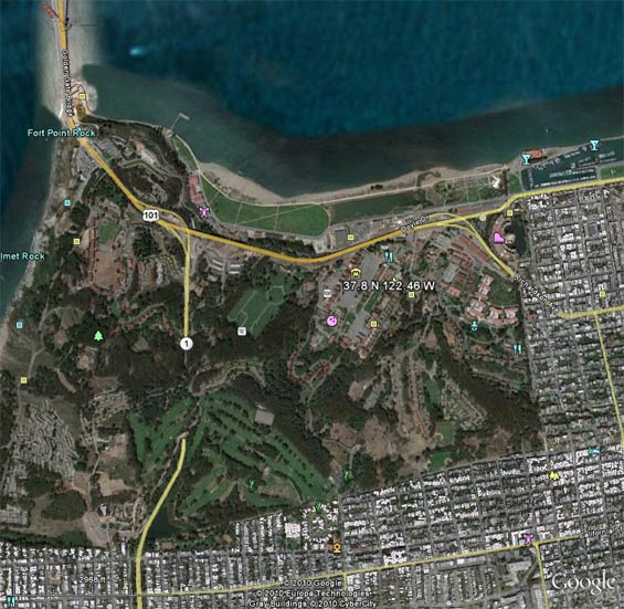
Below, a Google Earth view of the location of Crissy Field determined from the lat/long coordinates cited in the 1937 description, above. The coordinates cross at the center of this image. North is up. The southern approach to the Golden Gate Bridge projects upward in the top left quadrant. It is clear that the photo above was taken before construction of the Golden Gate Bridge. Actually, the location of the landing field was more in the horizontal area of the comma-shaped grassy area just north of route 101.
Crissy Field Location, San Francisco, CA, 2010 (Source: Google Earth)
 |
The history of the demise of Crissy Field is at the link. At the link, you can see an image of Crissy from the air that shows exactly the comma-shaped geometry. The field ceased fixed-wing operations in 1974. The entire Presidio base was closed by the Army and turned over to the National Park Service in the 1980's. The runway was taken up between 1998-2003.
Interestingly, co-located with the site of the original Crissy Field is the Internet Archive and the Wayback Machine, whose modest mission is, "universal access to all knowledge." Indeed, for aviation history buffs interested in the Davis-Monthan Register, www.dmairfield.com (the mirror site of the one you are currently working with, dmairfield.org) is archived there. This is indeed a serendipitous juxtaposition at 37.8 N and 122.46 W.
We have a photograph of one Register airplane, Douglas 28-129, on the ground at Crissy Field.
---o0o---
THIS PAGE UPLOADED: June, 2005 REVISED: 12/23/10, 12/17/14, 01/07/15
|