|
There were three major airfields in the San Francisco Bay area during the Golden Age of Flight. There were more, but the Oakland Municipal and San Francisco Airports were prdominant, as was the briefly popular San Francisco Airdrome (SFBA). The Alameda Naval Air Station had its origin as WWII began in 1940-41 and did not carry Golden Age traffic.
Oakland International and San Francisco International still operate as major airports. The early Oakland Municipal and SFBA are documented on this page. Please direct your browser to the link for a description of the San Francisco Municipal Airport.
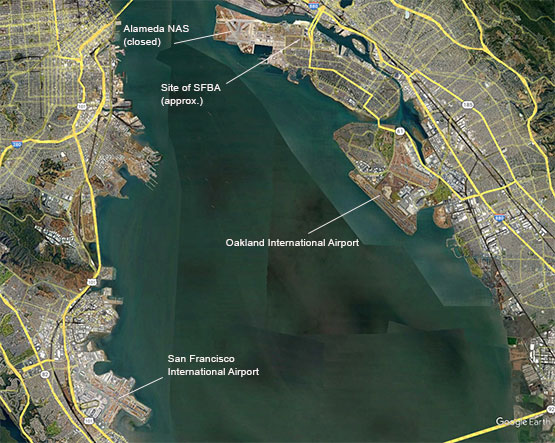
A Web Site dedicated to the Register of the Oakland Airport, 1927-1938, is in the works at oaklandairfield.org. Many of the aircraft and pilots of the Oakland Register included SFBA or San Francisco as parts of their itineraries. Of 13,042 landings recorded in the Oakland Register, 7.5 percent of the pilots (N=2,239) identified their home base as SFBA, Alameda, and 9.2 percent (N=2,750) identified their home base as San Francicso. This is not surprising, given the airfields were so close: they were less than a dozen miles from each other as the crow flies.The contemporary positions of the San Francisco Bay area airports are shown in the following image from Google Earth.
San Francisco Bay Area Airports Past & Present, 2022 (Source: Google Earth)
 |
Oakland Municipal Airport:
During the period of the Davis-Monthan Airfield Register, Oakland was a large airfield south of Oakland and east of San Francisco. It was an advanced airfield, with five hangars, a radio range beacon, weather reporting and traveler amenities (hotel, etc.) available at the field.
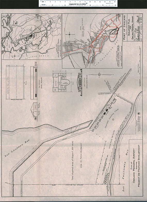
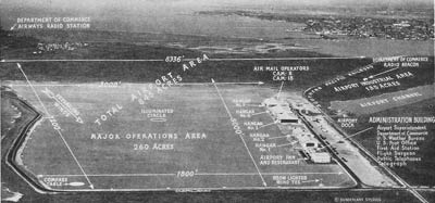
In 1927, the airfield was laid out as in the following schematic drawing dated August 1927. I exhibited this schematic lengthwise for better readability.
Oakland Municipal Airport, August 1927 (Source: Webmaster)
 |
Oakland Municipal Airport, Ca. 1931 (Source: Webmaster)
 |
A short film shows the Oakland Airport operation circa 1928. Note the Boeing Model 40 mail planes, and the large Western Air Express Fokker F-10 trimotor. This is a silent film. Please let me KNOW if this YouTube link becomes inoperative (works as of 12/13/22).
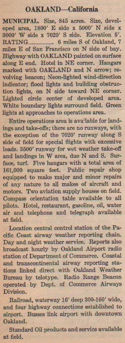
At left, from this REFERENCE, page 54, a description of Oakland, ca. 1931. The entire field was available for landing and departing traffic. There were no formal runways except one, a long one on the south side of the field used for special flights (excessive loads). All this in 1931.
Oakland would be famous in spite of it being the departure point for two historic Golden Age flights. The first was the August, 1927 trans-Pacific Dole Race. That race was won by Register pilot Art Goebel and his navigator, William V. Davis, Jr. Two books about these by your Webmaster are available for your enjoyment. They are listed in the left sidebar.
The second flight was the unsuccessful around-the-world attempts by Amelia Earhart in her Lockheed 10A NR16040 (not a Register airplane). The first attempt was in March, 1937, which was terminated by a ground loop accident in Hawaii. Her second departure from Oakland was in May, 1937, and ended with her disappearance somewhere in the Pacific Ocean on July 2, 1937. There is a movie on dmairfield.org that shows Earhart and her Lockheed on the ground at Oakland. The probablility is high that she appears in this film in March or May of 1937.
Interestingly, the film was shot by one of the Oakland Municipal Airport's business owners. West E. Moreau operated out of hangar 4 at the field. Please direct your browser to his link to learn about this productive Golden Age aviation entrepreneur.
Oakland Municipal Airport, Ca. 1933 (Source: Webmaster)
 |
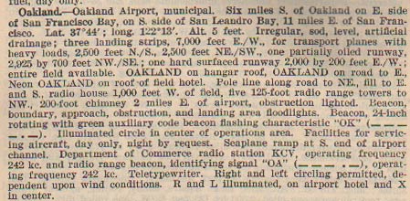
At right, from this REFERENCE, page 24, an aerial view of the northern California Oakland Municipal Airport, ca. 1933.
In 1933, Oakland Municipal was rated A-1-A by the Department
of Commerce. At the field there was a radio range beacon station,
Department of Commerce Aeronautics Branch Headquarters, U.S.
naval Reserve Base aviation unit and radio telephone.
It was located six miles south of Oakland and seven miles
east of San Francisco. It was irregular in shape and situated
on San Francisco Bay (see photo). An advance from 1931, above, the airfield now had two gravel and earth
runways, 7,050 ft. E/W and 3,500 ft. N/S. It was five feet
above sea level. It had facilities for landing seaplanes north
of hangar No. 5. There was no landing or flood light charge.
Day markings at the airport included the standard circle, "OAKLAND"
painted on hangar No. 1 and on the road east of the field.
A north indicator arrow was painted on hangar No. 2. For night
operations, it had boundary and flood lights, and a rotating
beacon with green code flashing "OK".
For communications it had telephone and two-way radio. Boeing
Air Transport, Inc. maintained radio station "KFO"
and the Department of Commerce maintained radio station "KCV".
Weather reports were available on the field.
A modern hotel and restaurant were still at the field. Taxi rate
to the city was 15 cents and buses ran every forty minutes
beginning at 8:06 AM. Fuel, oil and hangars were available,
as was a 24-hour licensed repair depot with licensed mechanics.
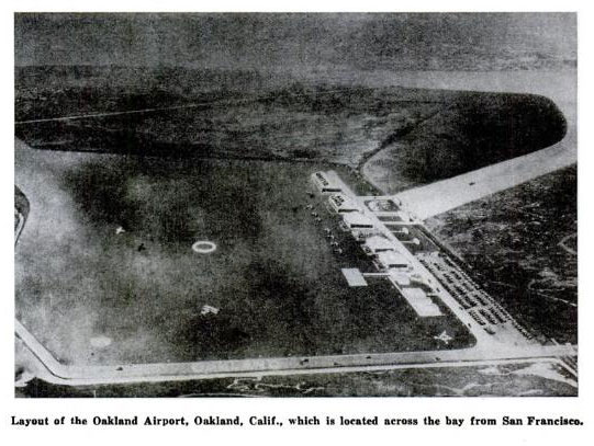
Below, from Popular Aviation (PA) magazine, June, 1935, is a view of the airport similar to the lableled one, above. Note, however, the new geometry of the channel at center right, which allowed for a seaplane launch. There are two aircraft aloft in this photograph.
Oakland Airport, Popular Aviation, June, 1935 (Source: PA)
 |
Operators on the field included United Air Lines and eight
flight schools: D.W. Wright's aerial school, W.H. Fillmore's aerial school, Monarch Air
Service, Moreau Flying Service, Vowles Flying Service, Boeing
School of Aeronautics and Derby Flying Club. Service, parts
and accessories were available from Pacific Aeromotive Corp.,
Western Aviation Supply Co. and Spillane & Co.
Below, from this REFERENCE, page 22, a description of the airfield from 1937.
Oakland Municipal Airport, Ca. 1937 (Source: Webmaster)
 |
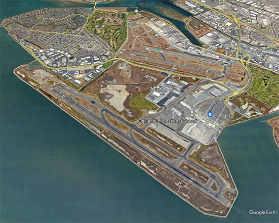
Below, from Google Earth, a 2022 view of the Oakland International Airport. North is up; San Francisco Bay is in the lower left corner. The contemporary airport has two sets of runways. The northernmost built on the same property as the original. The southernmost built on landfill into the Bay.
Oakland International Airport, 2022 (Source: Google Earth)
 |
If you go to Google Earth and explore some of the street names in the airport neighborhood, you'll find Maitland Drive, Earhart Road, Cessna Street, Doolittle Drive and Hegenberger Road, Loop and Place. All named after Register pilots for their aviation activities at Oakland.
San Francisco Bay Aerodrome (SFBA), Alameda, CA:
Below, courtesy of the San Diego Aerospace Museum Flickr Stream (SDAM), is a ground-level view of the airport dated October 30, 1930. The roof of the hangar is painted with the words, "San Francisco Bay Airdrome."
"San Francisco Bay Airdrome," October 30, 1930 (Source: SDAM)
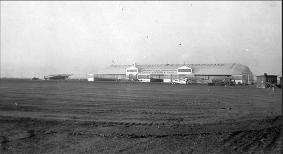 |
An interesting aspect of this photograph is that one of the two Fokker F-32s operated by Transcontinental & Western Air (TWA) is visible at the left of the hangar. These huge, four-engine aircraft were the largest operating at the time. They are Register aircraft and may be viewed at our Grand Central Air Terminal Web site (NC333N), and at the Parks Airport Web site (NC334N), respectively.
San Francisco Bay Airdrome (Source: Link)
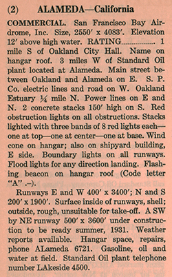 |
At left is a 1931 description of SFBA from this REFERENCE, page 11. After being founded in 1927, it was designated a commercial field. The presence of the TWA Fokker F-32, above, corroborated the designation.
Aerofiles.com, at the link, has additional information concerning SFBA, including aerial photographs of the field from 1930, 1937, 1940 and 1947.
SFBA was another that became a victim of the Great Depression and WWII. Early commercial airline residents decamped to the nearby San Francisco and Oakland Airports, leaving SFBA as a mostly general aviation field by the mid-1930s.
In 1941 as WWII spooled up, the governnent converted land to the northwest of SFBA into the new Naval Air Station Alameda. SFBA was then inactivated mainly because of NAS traffic interference, and partly because the Navy acquired land for housing that encroached on SFBA property. Today there is nothing left of the San Francisco Bay Airdrome, the land having long ago succumbed to housing and commercial purposes.
---o0o---
UPLOADED: 06/05 REVISED: 12/20/10, 12/17/11, 06/29/14, 12/06/19, 12/18/22
|