|
Several Golden Age airfields dotted the Greater Pittsburgh area. Five of them are described below in a listing courtesy of this 1937 REFERENCE.
Greater Pittsburgh Area Airports, 1937 (Source: Link)
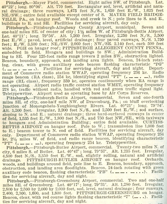 |
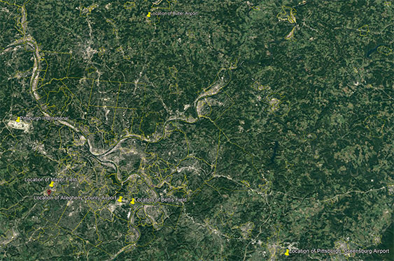
Below is a Google Earth map with yellow pins inserted at the locations of the five airfields specified by latitude/longitude values in the listing above. You might need to zoom your page to read the pins. I also identified the Greater Pittsburgh International Airport (PIT, far left), which opened in 1952. All the Golden Age fields are no more, except for Butler and Allegheny County, which still operate.
Locations of Five Pittsburgh -Area Golden Age Airfields & PIT (Source:Google Earth)
 |
MAYER FIELD
An excellent Web resource for Mayer Field is at the link. This link contains information as well as some excellent aerial photographs of the field. Established in 1919, as was the case for many vintage airfields, the site of Mayer Field became the Great Southern Shopping Center in the mid-1960s.
A Ryan aircraft. NC4942, a Pitcairn Field and Oxnard Field Register airplane, is seen at the link on Mayer Field ca. 1931. The important detail about this image is the "MAYER - FIELD" painted on the hangar roof at right rear. Note the "keystone" registration number painted on the side of the fuselage, indicating the airplane was registered in the state of Pennsylvania. Note also the obligatory shadow of the photographer. He is wearing a fedora and looking down into the range finder of his camera. From the coat on the woman, it is probably June in Pittsburgh!
ALLEGHENY COUNTY MUNICIPAL AIRPORT
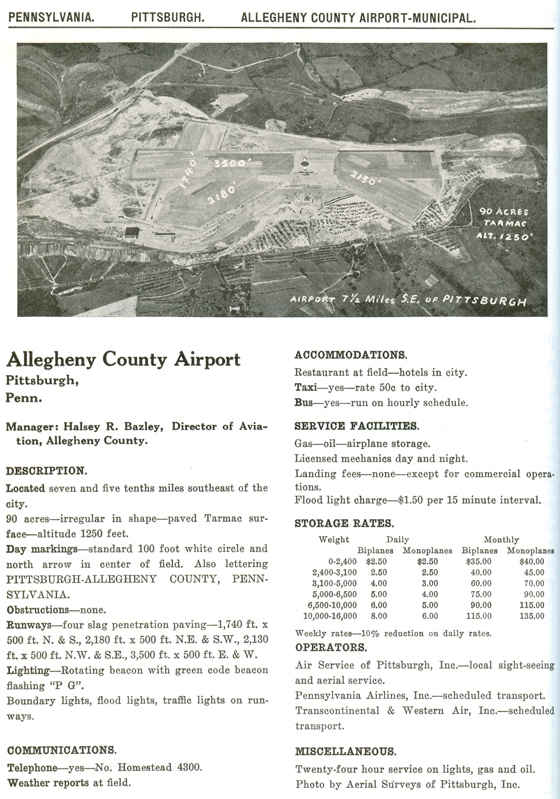
The description of Allegheny County Airport is the second one down in the description at the top of the page. The aerial photograph below is from this REFERENCE from 1933. Dedicated on September 11, 1931. Allegheny County is still an operating airport in the Pittsburgh area, catering to private, corporate and light commercial traffic.
Allegheny County Airport, Pittsburgh, PA, ca. 1933
(Source: Link)
 |
BETTIS FIELD
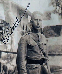
The Pittsburgh-McKeesport Airport was named Bettis Field in memory of Cyrus Bettis (1893-1926). The photograph, left, is from his U.S. passport application submitted in 1923. The airfield is described as it was in 1937 about halfway down the descriptions at the top of the page.
Bettis was an Army flier who died as a result of an airplane crash. The accident was reported in the Kingston Daily Freeman (NY), August 25, 1926, below. Although he survived the crash, he did not survive his injuries. He died at 9 A.M. on September 1, 1926 in the Walter Reed Hospital in Washington, DC where he had been flown by an Army ambulance plane.
Famous Aviator Found Alive in Penna. Woods
Lieut. Bettis, Army Flying Ace, Missing Since Monday Is Found - Injuries serious But Not Dangerous - Owes Life to Grit - Weak from Loss of Blood.
Bellefonte, Pa., Aug. 25 (UP) - Lieut. Cyrus K. Bettis, army flying Ace, missing since Monday, was found alive in the Seven Sister Mountains today and is now in the Centre County Hospital here in a serious but not dangerous condition.
The flyer's left leg is broken below the knee; his skull is fractured in two places and he has severe lacerations on the face and head.
Owes Life to Grit.
The army officer owes his life to his grit. Buried deep in the thick forest where no one could find him or his wrecked plane, he crawled for five and a half hours through the tangled underbrush until he came to a roadway where he was later found by two state highway employees.
On Way To Michigan City.
Accompanied by two other planes Lieut. Bettis was flying from the sesquicentennial grounds, Philadelphia, to Selfridge Field in Michigan, when he ran into a fog on Monday afternoon approximately twenty miles southeast of Bellefonte and lost his way. In searching for a landmark he crashed against the side of a mountain and fell. This was at 1:15 p. m.
Plane Catches in Tree.
In falling one wing of the plane caught in a tree and the machine wrapped itself around the trunk, breaking the force of the fall. Whether Lieutenant Bettis was rendered unconscious in striking the ground is not yet known as he is in no condition to talk. What information was obtained was given by him to the highway employees enroute to the hospital.
Found on Main Highway.
Bettis was found on the main highway running from Lewistown to Bellefonte. The section of the road where he lay when picked up is under reconstruction and all traffic is detoured three or four miles away. He was discovered in the road at 8:30 a. m. by Ralph Snyder and Russell Sweetwood who were driving along in an automobile on their way to work on the road. He was lifted into the machine and rushed here.
Officer Very Weak.
The lieutenant was very weak from loss of blood and lack of food and water, and the two highway employes did not question him too much. He told them of having managed to crawl from the wreckage of his plane and for hours calling for help. He feared to leave the plane as it was a marker from the air, in the event a searching plane located the wrecked machine. |
Alyn Trego, Bettis Airport Manager. 1927-36 (Source: Bybee)
 |
The New York Times, November 3, 1926 (Source: NYT)
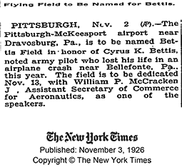 |
The New York Times of November 3, 1926, right, announced the naming of Bettis Airfield in his honor, . Two months later, several thousand persons attended the dedication of Bettis Airfield.
Bettis Field no longer exists. The given lat/long coordinates place it just to the south, adjacent to the
Bettis Atomic Power Laboratory. The Laboratory is, in fact, built over the airport property. The slight displacement could be due to rounding errors or mismeasirement of the latitude and longitude values. The Laboratory, which was once owned by the Westinghouse family, today performs research and development for U.S. Navy submarine nuclear propulsion systems.
An early manager of Bettis Field was Alyn Ernest Trego, left, in an undated news article. The photo was probably taken after December 1942, but before the end of WWII. Trego has no Web presence I could find.
More on Bettis Field is at the link. It includes
photographs depicting the history of the field.
BUTLER COUNTY AIRPORT
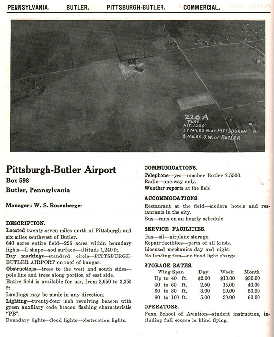
Butler Airport is described in the second entry from the bottom in the 1937 list above. It is still an operating, single runway airport about 25 miles north of the greater Pittsburgh area. Below is a description from this 1933 REFERENCE. The yellow location pin on the map above is displaced a little to the north of the field.
Butler County Airport, Pittsburgh, PA, ca. 1933
(Source: Link)
 |
PITTSBURGH-GREENBURG AIRPORT
Opened for business ca. 1920s, a good summary, with photographs, of the Pittsburgh-Greenburg Airport and its operations is at the link. The airport closed ca. mid-1950s and a photograph at the link shows the property built up with homes ca. 1962.
---o0o---
THIS PAGE UPLOADED: 10/25/10 REVISED: 12/26/22
|


