Landing Fields!!

View products that support dmairfield.org

OTHER RESOURCES

Your copy of the "Davis-Monthan Airfield Register" with all the pilots' signatures and helpful cross-references to pilots and their aircraft is available at the link. Or use this FORM to order a copy signed by the author. ISBN 978-0-9843074-0-1.

---o0o---

http://www.cafepress.com/content/global/img/spacer.gifThe Congress of Ghosts is an anniversary celebration for 2010.  It is an historical biography, that celebrates the 5th year online of www.dmairfield.org and the 10th year of effort on a project dedicated to analyze and exhibit the history embodied in the Register of the Davis-Monthan Airfield, Tucson, AZ. This book includes over thirty people, aircraft and events that swirled through Tucson between 1925 and 1936. It includes across 277 pages previously unpublished photographs and texts, and facsimiles of personal letters, diaries and military orders. Order your copy at the link, or use this FORM to order a copy signed by the author.  ISBN 978-0-9843074-4-9.

---o0o---

 
Davis-Monthan Aviation Field Register
CulturalMotion PicturesFriendsNon Profit statusProducts and services
ReferencesPublicationsCollectionsGuest EditorsPress Coverage

CALEXICO, CA MUNICIPAL AIRPORT

Calexico Municipal Airport, 1931 (Source: Webmaster)


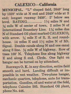
At left, from this REFERENCE, page 18, is a description of the Calexico Municipal Airport in 1931. Note that it states that the airfield is 2 miles north of the international boundary line. That would place it north of Cole Rd. and not in the area of the contemporary airport.

Additionally, a quarter mile east of the railroad tracks would place it near the property of the Calexico Freight Lines and Fed Ex Freight. If you go to Google Earth and look around that area, there are no remnants of an airfield.


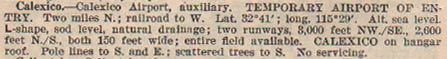
Below, from this REFERENCE, page 14, is a description of the airfield in 1933. The airfield remains 2 miles north of the border and east of the railroad. I am not sure of when the airfield changed locations. Does anyone KNOW?

Calexico Municipal Airport, 1937 (Source: Webmaster)

Your Webmaster visited Calexico Airport on September 23, 2002. Below, two views of the airport. First, the ramp at ground level. This was a hot, clear, cloudless desert day. The airport was deserted, save for the airport manager and office staff.

Calexico Ramp, September 23, 2002 (Source: Webmaster)

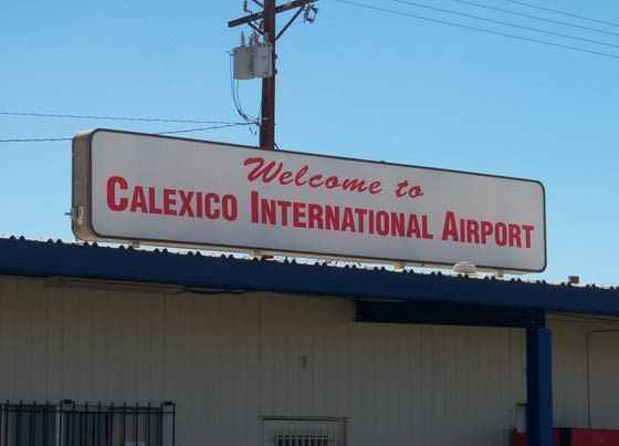
Below, the sign over the terminal building. About 500 feet beyond this building is the U.S.-Mexican border. In addition to Bisbee and Douglas, AZ and El Paso, TX, thirsty Prohibition-era pilots used Calexico as a convenient weekend port of entry into Mexico where alcohol was freely available.

Calexico Terminal Sign, September 23, 2002 (Source: Webmaster)

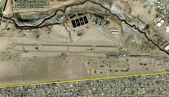
Below, a Google Earth view of the Calexico airport from 2010. The sign, above, is on the middle building of the three small ones near the bottom third of the photograph. The yellow line is the U.S.-Mexico border.

Calexico International Airport, 2010 (Source: Google Earth)

---o0o---

THIS PAGE UPLOADED: 12/15/10 REVISED:

 
Home
The Register
People
Places
Airplanes
Events
YOU CAN HELP
I'm looking for information and photographs of this airfield to include on this page. If you have some you'd like to share, please use this FORM to contact me.
 
Contact Us | Credits | Copyright © 2008 Delta Mike Airfield, Inc.
This website is best enjoyed in a 1024 x 768 screen resolution.
Web design by The Web Professional, Inc