|
El Paso Municipal Airport, Ca. 1931 (Source: Webmaster)
 |
In 1931 there were three airfields in El Paso, TX. There was a municipal field, which served the civil pilots who signed the Register at Tucson. This field was not at the same location as the contemporary El Paso International Airport (see below).
There was a military facility, Biggs Field, that served military pilots, and a private field, established in 1929, that served airlines (this site became El Paso International Airport). All three were fairly close together geographically.
El Paso, as well as Los Angeles, CA, was a very popular entry in the Davis-Monthan Airfield Register. And little wonder. Both cities, along with Tucson, were on the predominant low-altitude, east-west route between the west coast and the rest of the U.S.
As written in the Register, 29 flights identified El Paso as their home base. However, 861 flights arrived from El Paso and 676 flights identified it as final destination. This doesn't mean that all the flights began or ended in El Paso.
Rather, El Paso (like Lordsburg, NM) was a common rest or fuel stop before heading west for the nearly three-hour flight to Tucson. Or, conversely, it was a good place to stop eastbound from Tucson before proceeding farther east.
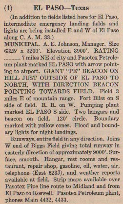
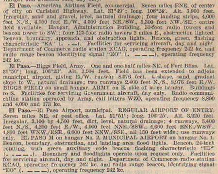
At right, from this REFERENCE, page 28, is a description of the municipal airfield at El Paso as it existed in 1931. In response to Lindbergh’s flight and subsequent tour of the U.S., El Paso built their first Municipal Airport and opened it September 8, 1928. It was pretty much as described at right. This is the field that most civil pilots transiting Tucson referred to when they wrote "El Paso" in the Register.
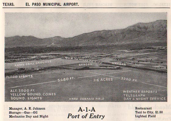
Below, from this REFERENCE, page 221, is an aerial photograph of the Municipal airfield. The view is to the southwest. For an image of a Register aircraft on the ground at El Paso, please direct your browser to NC9724. This is a Standard Air Lines transport aircraft at the Municipal airfield. Standard would in 1929 establish its own field nearby.
El Paso Municipal Airfield, Ca. 1933 (Source: Webmaster)
 |
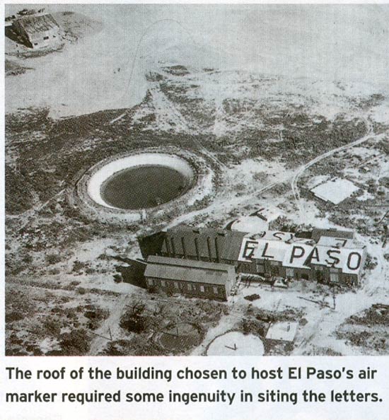
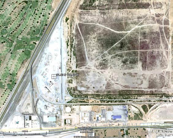
Below, a view of what appears to be the "pumping plant marked EL PASO" described in the 1931 reference above, with a round water holding tank. The view is roughly from the south. If you look very carefully in the image above, you will see under the word "GROUNDS" at left, the smoke stacks extending above the building. The round water tank is the banked oval form just in front of them.
El Paso, TX, Date Unknown
 |
Below, a Google Earth image of the same location (31.83 N 106.43 W) as the original Municipal airport. The round water holding tank is visible in the lower left quadrant. I looks filled with sand today. The municipal golf course is shown at left, which was present with the field was established in 1928.
Site of Original El Paso Municipal Airport, 2010 (Source: Google Earth)
 |
El Paso Military and Commercial Fields, Ca. 1931 (Source: Webmaster)
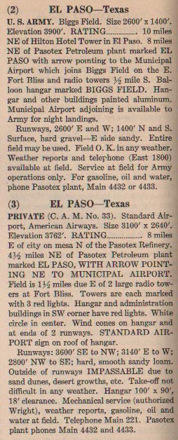 |
At left, from the REFERENCE cited above, page 28, are descriptions of the military and commercial fields.
The second El Paso field is Biggs Field. It began as Fort Bliss Flying Field somewhere around 1917, but in June 1919 DH-4s were flown in to initiate the Aerial Border Patrol. The Field was renamed Biggs Field (to honor a local flier lost in WWI) in 1925, closed in 1926, and relocated two miles east at a WWI National Guard camp with the new name of Biggs Army Airfield. Though closed, Fort Bliss/Biggs Field continued to provide a field for transient aircraft (civilian and military) till the early 1930s.
Biggs Field began originally as the location of a balloon hangar erected for an Army Airship, C-1, to fly the Border Patrol. There were to be six hangars built along the border, but the one at Biggs was the first and only one completed and was used for a brief time until the Aerial Border Patrol was ended and C-1 relocated.
The balloon hangar was placed in caretaker status until 1939 when Biggs was reactivated, funds made available and an expansion program for WWII was begun. Biggs expanded, was a B-24 training base during the war, became a SAC base (B-36s, B-47s, B-52s) and eventually reverted back to the Army airfield it is today. The balloon hangar was torn down in 1956.
Biggs is further described in the document you can access by the link at the bottom of the left sidebar. Namely, "Biggs Army Air Field in El Paso County was originally named Biggs Field for Lt. James A. Biggs, an El Paso pilot killed in France in 1918. Though after World War I Biggs Field became the station of the First Surveillance Group, it was little more than a refueling stop until the outbreak of World War II, when it was greatly expanded by a $10 million construction program. In the summer of 1942 it became headquarters of the Twentieth Bomber Command and the Sixteenth Bombardment Operational Training Wing...."
And, further, "The remainder of the twenties and thirties were quiet years. Biggs field served Fort Bliss as a transient terminal until the establishment of the 20th Observation Squadron and a Tow Target Squadron in 1939."
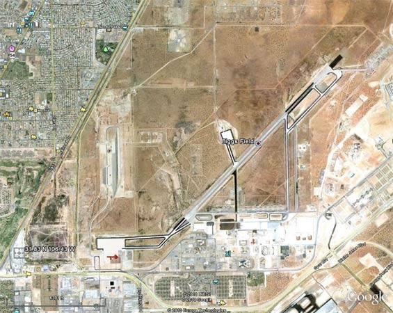
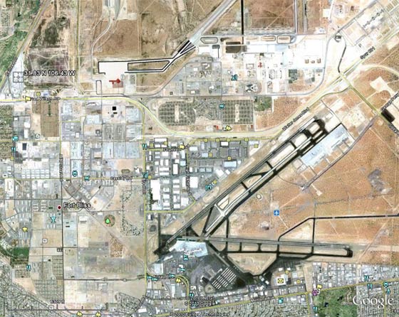
Below, a Google Earth image of the contemporary NE-SW runway of Biggs Field. Notice the coordinates, 31.83 N 106.43 W, at lower left. This is the position of the original Municipal airport described and pictured above. Its Golden Age juxtaposition with Biggs to the east is clearly illustrated. The golf course is also visible as an island of irrigated green in an otherwise arid environment.
Biggs Field, El Paso, TX, 2010 (Source: Google Earth)
 |
The third field is "Standard Airport," as described above. The Municipal airport was not well situated for commercial passenger transport service, because it was near the mountain. Standard Airlines recognized this early-on and built their own airport about two and a half miles south-east, opening it October 6, 1929. The city of El Paso tried to lure them back to the Municipal field, but finally was compelled to buy the airfield from American Airways (who had bought Standard from WAE/TWA in 1930) when the Civil Aeronautics Administration denied further funds because they also felt the original airport was too close to the mountain.
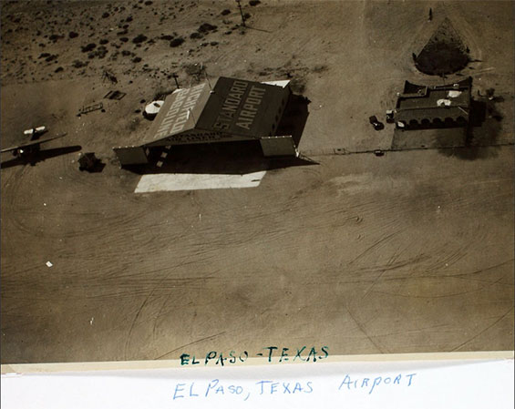
The Standard Airport property eventually became the El Paso International Airport. Below, courtesy of the San Diego Aerospace Museum Flickr Stream (SDAM), is an undated aerial photograph of Standard Airport. The facade of the hangar is painted with "Standard Air Lines." The "administration building" is on the right and what appears to be a Fokker trimotor is visible at left. The left side of the hangar roof is painted "Richfield Gasoline."
Standard Airport, El Paso, TX, Ca. 1929-31 (Source: SDAM)
 |
Below, a Google Earth image of the contemporary El Paso International Airport. Its long runways are visible in the lower right quadrant. For reference, I left the coordinates for the Municipal airport and adjoining golf course in the upper left quadrant. The SW end of the Biggs Field runway is visible top, center. Compare this image to the ones above and you get a good idea of the closeness of all the original Golden Age landing areas.
El Paso International Airport, 2010 (Source: Google Earth)
 |
The International Airport began as the Standard Airport but was variously referred to as Airmail Field, American Airlines Airport, Ed Anderson Field, El Paso Municipal Airport and eventually El Paso International Airport. Because of Standard, the International Airport is located where it is now.
Below, from this REFERENCE, page 189, are descriptions of the three fields dated 1937. The "Irregular, sand and gravel" runways described for the American Airlines field are very different from the well-maintained asphalt versions in the photograph just above.
El Paso Airfields, 1937 (Source: Webmaster)
 |
Biggs in 1937 had an E-W runway; different from the contemporary field pictured above. Note that the individual airfields all had their own distinct communication radio stations. The Municipal field had a radio range beacon.
In addition to the above, El Paso's abandoned airports are available to view at the link. Our interest is in the El Paso Municipal Airport at the top of that link. This would be the airfield that most of our civilian pilots headed for after itrs establishment in 1928.
If you scroll down to the fifth image on that page, the 1936 aerial photo, you will be able to align the round water reservoir and building of the El Paso Water Works in that image with the ones above. Interestingly, if you magnifiy the image at the link, you can make out the white roof and shadows of the smoke stacks on the buildings. You can also see, to the left of the tank, what appears to be a high-wing monoplane on final approach to the runway. It casts its shadow on the ground ahead of itself. The other two buildings have writing on their roofs, but it's not legible.
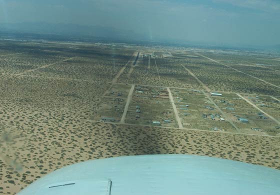
Finally, Your Webmaster landed in the El Paso area on September 12, 2002 to begin a unique flight that was common to Register pilots of the Golden Age. The Horizon airport is a small, single-runway field about 8 miles southeast of El Paso International. Below, the final approach to the E-W runway at Horizon. The desert and mesquite are similar to what Register pilots saw when they approached the original three El Paso airfields. The pass that gives El Paso its name is visible through the haze in the upper right quadrant.
Horizon Airport, El Paso, TX, September 12, 2002 (Source: Webmaster)
 |
The flight I began here headed west, straight for the pass. I picked up the railroad tracks on the other side of the pass, just south of the Santa Teresa airport. Then I followed the tracks, with the full cooperation of Albuquerque Center, low and slow (when I told them my purpose they thought it was a great idea). I passed Deming, NM and flew on into Lordsburg, NM. From Lordsburg I flew to and landed at Douglas, Bisbee and Nogales, AZ, and on into Tucson. Please direct your browser to the links to see other views of this flight into the past. It gave me a good appreciation of the Golden Age sights and smells. If you're a pilot, try it sometime.
---o0o---
UPLOADED: 12/17/10 REVISED: 12/08/14
|