|
PIONEER HOTEL
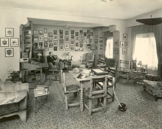
One of the most interesting places to visit
in Tucson during the Golden Age had to be the Aviator's Lounge
at the Pioneer Hotel (opened ca. 1929). The image below has been optimized
for web download, but this room is so interesting that I
want you to examine it in more detail. Click here to
download the same image at 400dpi (it's a 10MB file, but
worth the wait).
If you do one extra thing on this site,
do this download and explore this photograph! It doesn't get much better than this! To help, I have identified some of the people in the photographs on the back wall. Move your cursor over the photos until the hand and identifier label appear. Click to follow the link for additional information.
Aviator's Lounge, Pioneer Hotel, ca. 1929
|
Now, with your 400dpi image open in your image viewer, zoom
in on the objects in the room. It's a genuine treasure house
of Golden Age lore.
Start with the easy stuff. How many piston ashtrays can
you find? How many aircraft engine cylinders are there (how
many are air-cooled; how many water-cooled)? Notice the magazines;
poker chips; the Golden Age Rollodex at the center of the
table and the "Script" lying next to it; the humidor
and cactus on the end table near the window; the iron straps
and leather sling seats on the southwest-themed furniture (you can hear the wood and leather creak);
the ashtray on the art deco stand in front of the right-most
easy chair.
How many spitoons? Note one of the most
disgusting objects on this Web site just right of midline:
a 'relief tube' hooked to the
edge of the table leads to the spitoon ! Great fun for those watching those who
dared to use it!
You can see half of a huge propeller at
the ceiling line, right. The gentleman in the chair, posed
with Cat's Paw heels and reading "Western
Flying" is George
Benefield. a pilot who landed at Davis-Monthan on Friday, August 29, 1930. He was also manager of the Hotel at the time.
Now for the really great part of the high-resolution image. Zoom in on the pictures on
the back wall. Just above and to the left of Benefield's
head is an image of T.V.
Foster riding a mule. Directly above Foster is a young
Jack Frye.
Farther up and right are Orville Wright and Charles
Lindbergh. At 2 o'clock and 4 o'clock from Lindbergh
are Carl Spatz and Richard Byrd, respectively.
At the top, right corner of the wall is a group of five
principals of Standard Air Lines, Harold Kelsey, William Kingsley, Paul
Richter and Hap
Russell among them. Can you
recognize any of the others from images on this site? Please
spend some time with this image. If you recognize other items
and people, please let me know through this FORM.
What about the heraldry on the wall, left front and right rear? At left front, at 9 o'clock is the emblem of, what was probably at the time, the 5th Group (Composite). Its motto, "Kiai o ka Lewa" is readable when you magnify the image. Likewise, "Sicitur ad Astra" (such is the pathway to the stars) was the motto of the Canadian Air Force when it was founded in 1920.
NOW, for the two most mirthful items in the room. One has to be the easy
chair and ottoman in the right rear corner. Is that an airplane
control stick standing up there behind the ottoman? You can
just picture the lucky guest who settles into this chair perhaps
sereptitiously sipping from a flask a forbidden beverage
(remember Prohibition was in effect until 1933). The tales
he'd tell, pushing the stick forward, about diving on Rebels
south of the border back in '24.... Or, pushing the stick right, how he'd barrel roll
out over the dry lakes west of Lordsburg just for the hell
of it, or the time he had to make a forced landing in mesquite
just short of Yuma on his way to Mines because he ran
out of gas fighting headwinds.... Or that gal he met in
Silver City.... If only these walls could talk!
The Log of the Aviator's Lounge in the Pioneer Hotel, Ca. 1930s
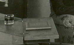 |
The second is the sign-in book for the Aviators's Lounge. This book is actually present in the photograph above. You can see it lying on the desk just off Benefield's right elbow, right. Click the link for an exposition of the book contents and color images of all its pages. It's a treat!
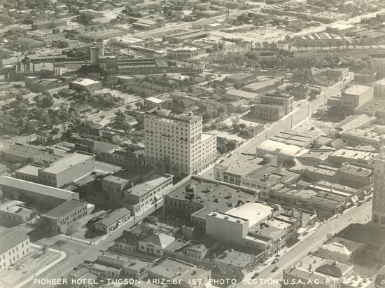
Below, a U.S. Army Air Corps aerial photograph from August 17, 1930 of the Pioneer Hotel (center) at 100 N. Stone Ave., downtown Tucson. You can see a water tower below the hotel. Painted on the tower is "STEINFELD'S" in a spiral pattern, readable from any angle. The ad is for Albert Steinfeld & Co., a Tucson merchandise company. Goods for the Steinfeld's were sometimes shipped by Standard Air Lines in NC9724. Other businesses, whose signs are readable on the original photo, include Sears Roebuck and Eagle Milling Co. Still in business across town, Eagle Milling wholesales and retails farm supplies and manufactures animal feed.
Pioneer Hotel, Downtown Tucson, AZ, August 17, 1930
 |
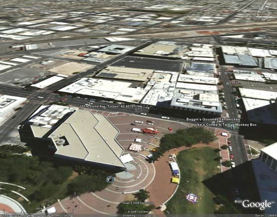
For comparison, below is downtown Tucson in 2008 as viewed with Google Earth from approximately the same angle. The view is roughly to the east at 2,800 feet. The railroad tracks remain in the background. At the center of the image is the approximate location (it's a little too far north) of 100 N. Stone Ave. The old Pioneer Hotel building is on the southeast corner where the Baggin's Gourmet Sandwiches and Monkey Box labels are. The City Hall area is across Stone Ave. at the bottom of the image. West Pennington Street is to the south and West Alameda St. (with the right dogleg) to the north.
Downtown Tucson, AZ, 2008
(Source: Google Earth)
 |
The 12-story Pioneer Hotel opened in 1929. It had 250 rooms
and 22 suites -- all with private baths and circulating ice
water. Rates began at $3 per night. In its heyday,
it was known as the premier hotel in Tucson and catered to
the business elite. Tragically,
the hotel burned on
December 20, 1970 with the loss of 28 people (one more succumbing
several months later). The sign-in book,above, survived, having been moved off-site probably years previously. Assuming the aviator's lounge still existed in 1970, does anyone KNOW if
any of the other artifacts in this room survived the fire and, if so, where
they are?
After the fire, the building was converted to offices with extensive remodeling and facade work in 1977. Later, John Hancock Mutual Life spent $1.3 million renovating the building, including hallways and other common areas. It sold in 2005 for $7.8 million. The new owners are considering removing a metal frame added to the top of the building in the 1970s. The goal is to restore its historic appearance. Would that the aviator's lounge could also be restored! Regardless, if you walk a block toward the railroad tracks along Pennington, you'll come to 110 East Pennington St. There you'll find the Cafe Poca Cosa, serving today the best northern Mexican cuisine on the planet. The Cafe used to be in the Pioneer Hotel in later years.
---o0o---
DAVIS-MONTHAN AIRFIELD
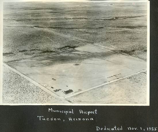
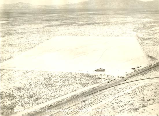
Below, the Davis-Monthan Airfield ca. November 1925. If
you want to explore the area a litlle bit, click here to
download the same but higher resolution image (1,200dpi;
30MB). The geographic location of this image is at the corner of 6th and Irvington in contemporary Tucson. The hangar building is still in place today. Please follow this link to see images of the airfield at that location then and now. Once at the page, click on "Macauley Field / Fishburn Field / Tucson Municipal Flying Field / Mayse Field" and scroll down.
Davis-Monthan Airfield, ca. 1925
 |
The images below are of artifacts associated with the dedication
of the Airfield on November 1, 1925.
Davis-Monthan Airfield Dedication Artifacts, November
1, 1925
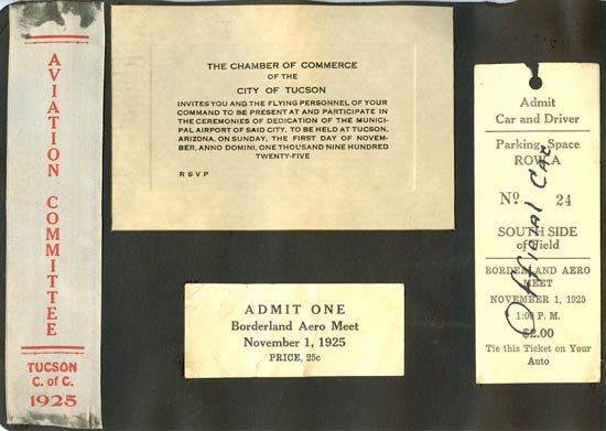 |
The history of the Airfield can be confusing. Take your pick of dates when you think the official birthday of the Airfield should be. If we look at it carefully, the Airfield was initially established in 1919 at the spot indicated above (birthday number one). The first "dedication" was on November 1, 1925, as indicated by the artifacts above (birthday number two). The Register was, in fact, opened initially at this location. The first entry on a line of the Register was by Les Arnold on Wednesday, November 4, 1925 at 5:15 PM
With Charles Lindbergh's success in 1927, it was again "dedicated" on September 23, 1927 when Lindbergh passed through Tucson during his post-trans-Atlantic tour (birthday number three). The U.S. Air Force has adopted this later date. The 80th anniversary of this dedication was celebrated at the Air Force Base September 14, 2007.
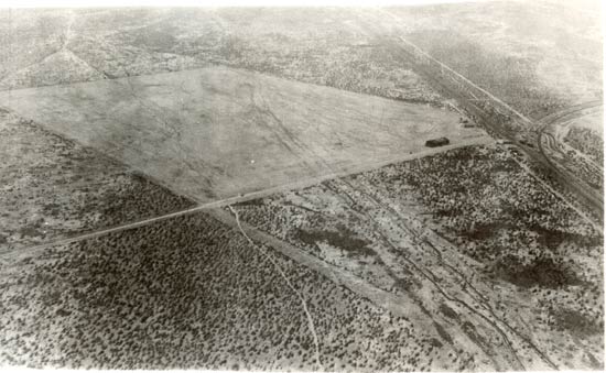
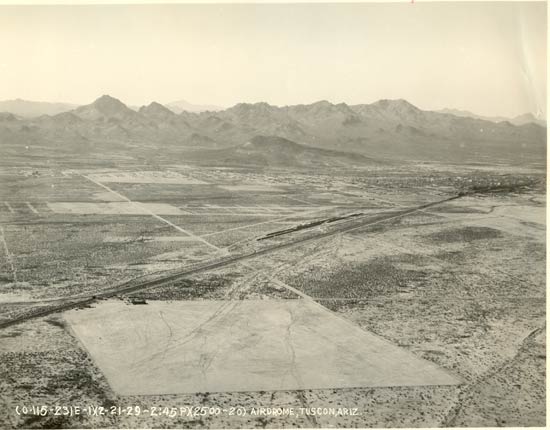
Below, an aerial photograph from Cosgrove's albums of the Airfield from February, 1929. By this time the facility was moved to the present location near Alvernon Avenue. The northwest corner of the Airfield is nearest us on the right. The Southern Pacific Railroad (now Union Pacific) runs diagonally, center right to bottom left.
Davis-Monthan Airfield, February 13, 1929, View 1
 |
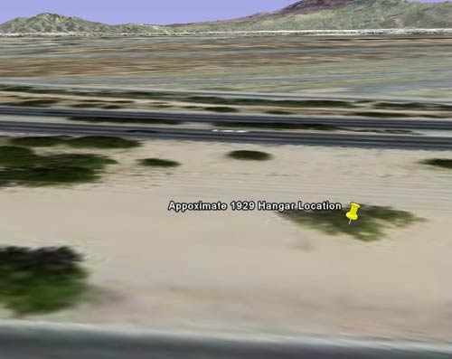
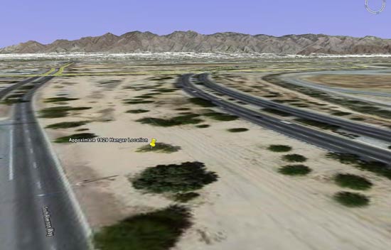
Look below to compare the image above with a contemporary Google Earth image from about the same orientation. Look carefully to the horizon and you'll see I keyed the Google Earth image to the mountains in the background. The image orientation is about 071 degrees, at an altitude of 2,600 feet. You're looking east northeast in the direction of Tanque Verde. The northwest corner of the old Airfield is under the roadway visible at image center. Please cut me some slack of a couple hundred yards and a few degrees or so.
2008 Google Earth Image of the Old Davis-Monthan Airfield Location
 |
Aerial image below taken from the northeast on the same day. These images are military photographs. Note the documentation at the lower left corner of each.
Davis-Monthan Airfield, February 13, 1929, View 2
 |
Below, an aerial image taken a week later looking north, the city of Tucson is visible center right. The diagonal line is the Southern Pacific Railroad (now Union Pacific). A railroad siding is at center.
Davis-Monthan Airfield, February 21, 1929, View 3
 |
Similar to the first February 13, 1929 image, below is a Google Earth rendition of the image above for February 21, 1929. The view is more northerly. The present Davis-Monthan Air Force Base is off this image to the lower left.
Google Earth Image of the Old Davis-Monthan Airfield Location
 |
Below are a couple of ground-level photographs. These were snapped by Cosgrove's Leica. We are lucky to have two images from about the same perspective taken about three years apart. Compare these with View 1, above. There are many, many changes in ground-level infrastructure recorded in these images. As well, there is conjecture as to the location of some of these structures. Please direct your browser to this link to review them.
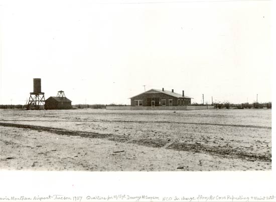
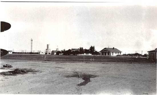
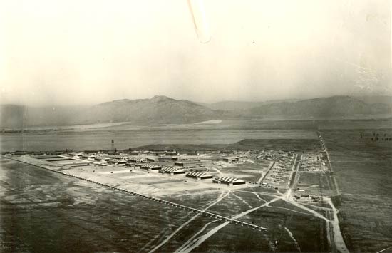
This first image below was taken ca. 1927. This was the year Lindbergh came to town on September 23rd. I have left Cosgrove's caption at the bottom of the image. It says, "Davis-Monthan Airport Tucson 1927. Quarters for M/Sgt Dewey H. Simpson. NCO in charge of Army air Corps Refueling & Maint Unit". To the left are two structures, one a small building with a platform on top, and the other a water tower on what looks like a steel stand.
Below, about the same perspective three years later. Simpson's quarters have been painted white and planted with trees, another structure was added to its right, and the picket fence has been extended to surround it. Just at the right edge of the image can be seen the American Airlines Terminal. The water tower looks like it has been painted white, the small building has been painted, and the platform on the roof has a structure on it now, perhaps a radio antenna or a weather station.
Davis-Monthan Airfield, Ground-Level, ca. 1930
 |
IDECO Tower Ad, 1928 (Source: Site Visitor)
.jpg) |
The significant change in this image is the appearance of the left-most tower. This is the "Lindy Light" (installed ca. 1929, does anyone KNOW the exact date?), a rotating green and white beacon visible at night to identify the airport. A site visitor says about the tower, "That original tower at Davis-Monthan was an IDECO [International Derrick & Equipment Company, see ad, right] tower of a type most commonly used by railroads to support floodlights in rail yards. The Southern Pacific RR was involved in the development of D-M and it contributed the tower for the "Lindy Light." The terminal and hangars were located next to the SP's main line through Tucson. As far as I know (so far), this was the only one of these railroad towers to be used as aviation beacon tower."
The biplane wing at the left edge of the photograph has what looks like a parachute lying on the ground to the rear of it. The stain at center foreground is probably engine oil spilled before the tailskid dragged through it. The Environmental Protection Agency was not around in 1930.
Question: What would be the location of the hangar building predominant in aerial Views 1-3, above? Answer: Over our right shoulder behind us. Further, although there are a few in the top image, it looks like there are more telephone lines installed along the railroad right-of-way, too. When you consider that these improvements were made as the Great Depression was deepening, it gives some idea of how important aviation was to Tucson, and the impact made by Lindbergh's visit.
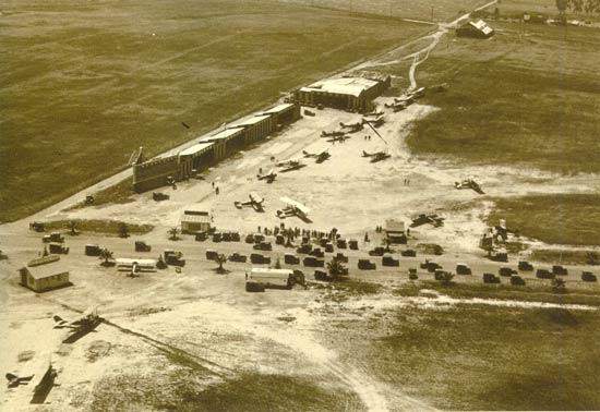
Hisso-Powered Consolidated PT-1, Date Unknown
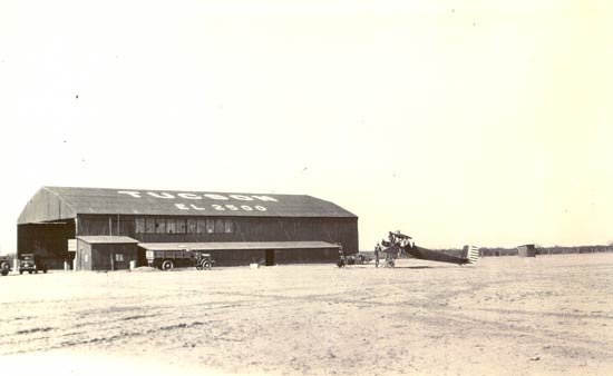 |
Above, the hangar viewed from a southerly position. The PT-1 is being worked on by maintenance people. Note there is a person kneeling about ten feet in front of the airplane. Looking at an enlargement of the original image, it appears he has a long object on the ground in front of him with what looks like a curled end. This could be a damaged propeller with the edge strip and cap curled away from broken wood stock. Just a guess.
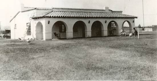
Below is a fine image of the American Airlines Terminal at Tucson. It was built ca. 1930. C.B. Cosgrove, Jr. can be seen sitting in a rocking chair with knickers and knee socks conversing with an unidentified woman. Note that large flood lights were installed on the ground (one in front of the woman, right; the other under the ladder, left), as well as the "Lindy Light" rotating beacon seen in the image above.
American Airways (Airlines) Terminal, Tucson, AZ, ca. 1931
 |
Below, a rare image of the inside of the American Airways (Airlines) Terminal building. This is the radio room photographed during 1931, and labeled "American Airways" at the bottom. After Standard Air Lines was bought in 1929 by what was to become TWA, American Airways became a predominant company in the southwest with a base at Tucson. On April 11, 1934 American Airways became American Airlines. Although 1931 is inscribed on the image below, we can safely assume the image above was taken sometime between 1930 and 1932, between the time when the building was erected, and when Cosgrove left his managerial duties at the Airfield.
American Airlines Terminal, Tucson, AZ, Radio Room, 1931
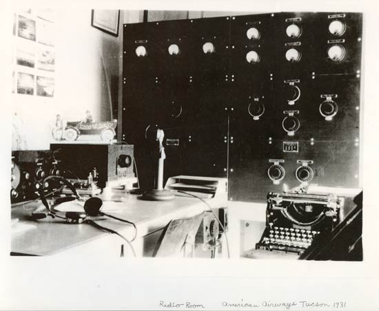 |
In the radio room we see an Underwood typewriter at lower right (the name just above the keyboard is readable on the original image), as well as the operator's headset and microphone on the desk. The photos on the wall appear to be images of cloud types. Perhaps these were used by the operator to give pilots some idea of the cloud cover, and therefore potential weather to be expected, at Tucson. Does anyone KNOW anything about the radio equipment? These days you can probably have this roomful of functionality, including the typewriter, in a hand-held device.
On top of the radio equipment box on the desk rests an Amos 'n' Andy Open-Air Taxi. It appears to be a cardboard profile, or perhaps a ceramic model on a wood base, of the taxi and the two characters. Actual tin models of the Open-Air Taxi with wheels and wind-up spring motors were popular toys of the era. Close examination of the original image shows the characters are white people in black face, as it was in the early days of the "Amos 'n' Andy" radio show, which originated in 1928. Times change.
---o0o---
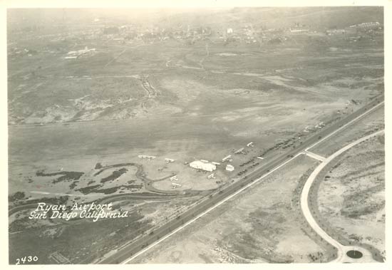
Below, three images of airfields from the greater San Diego area. The first image of Ryan Airport is undated. But close examination of the original photo shows a large high-wing monoplane just to the right of image center. There are many people milling around the airplane, and many cars parked along the edge of the field. There is white lettering on the side of the airplane, which makes it look like the Fokker "Josephine Ford", NX4204, which landed at Tucson on November
9, 1926. Please direct your browser to the link and scroll down near the bottom of the page. There you will see another image from a book that shows this same scene.
Ryan Airport, San Diego, CA, November, 1926
 |
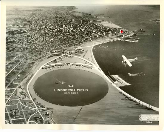
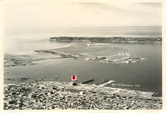
Below, Lindbergh Field facing southeastish along the Pacific coast in a stylized painting from a photograph. The plaque in the bottom right corner says, "Painted by Sunset Engraving Co. After Aerial Photograph by Erickson, 1927". Note the red arrow identifying a landmark building, the 11th Naval District Headquarters which still stands. The tip of North Island intrudes at upper right.
Lindbergh Field, San Diego, CA, ca. 1927
 |
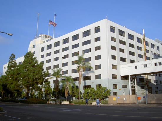
Below, North Island military airfield. Note the red arrow pointing to the same building as above. You may locate this building in present day San Diego by going to Google Earth and placing your pointer at 32°42' 54.98" N and 117°10' 20.69" W. You'll find a double building at these coordinates; the northernmost is the original HQ building.
This image is labeled 1956, but the date of the photo is undoubtedly much earlier. The San Diego Naval Air Station lies on the island and is identifiable by the large open space, which, early-on, it shared with the Army's Rockwell Field.
North Island, San Diego, CA, Date Unknown
 |
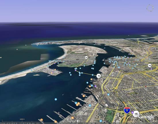
Below, a 2008 Google Earth view of North Island from approximately the same position as the image above. The runways of Lindbergh Field, the contemporary San Diego international airport, are visible center right.
North Island, San Diego, CA, 2008
 |
Below, a contemporary image by Mike Gerow of the 11th Naval District building.
2008 Image of the 11th Naval District Building
 |
---o0o---
Below, three images of March Field, Riverside, CA. This airfield still exists as the March Air Reserve Base at the intersection of Van Buren Blvd. and Interstate 215 in Riverside. The March Field Air Museum is there, housed in a building with orange and white checkerboard, as in the images below.
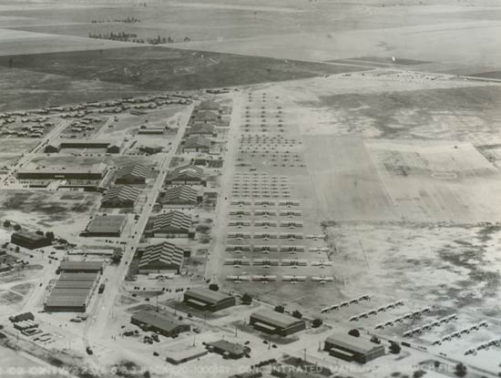
The first photograph is from May 8, 1932 taken from about 1,000 feet. The caption on the bottom of the image states "CONCENTRATED MANEUVERS". We can understand why, as there are 178 airplanes visible on the ground. There is no concentration of military air traffic in the Register at Tucson to suggest that some of these airplanes came from, for example, Army airfields in Texas to participate in these maneuvers (however, see the photograph of Wright Field, below).
March Field, Riverside, CA, May, 1932
 |
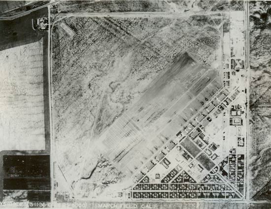
Below, March Field on March 11, 1936 taken from 8,000 feet straight overhead. The checkerboard roofs are evident in this and the image above. The landing circle, clearly visible at center right, above, is absent in the next two photographs.
March Field, Riverside, CA, March, 1936
 |
Below, March Field ca. 1938. The diagonal line from mid-left to bottom right is a rank of biplanes. A survey line must have been laid for the pilots to align with.
March Field, Riverside, CA, ca. 1938
 |
---o0o---
Below, an image labeled simply, "LA Airport, 1923". There was no indication of which Los Angeles airport, however on page 13 of the book by Wynn in the REFERENCES, this field is simple to identify as Chaplin Field at the corner of Wilshire Blvd. and Crescent Avenue. The vertical stripes on the buildings are distinctive and make the identification easy. Chaplin Field was used as a base for motion picture stunt pilots. From the cars and people around, it looks like a motion picture shoot is in progress.
"LA Airport, 1923"
 |
Interestingly, the building nearest the top of this photograph has writing on the roof that in the original looks like "Black Cats". The Black Cats were a motion picture aerial stunt organization from the 1920s, whose members included Register pilots Art Goebel and Paul Richter. Does anyone KNOW about the writing on top of the hangar and can confirm that it says "Black Cats"?
---o0o---
Below, Wright Field, Dayton, OH, May 17, 1931. Curiously, this image looks like it was taken in color. It was not; the greenish tint being an artifact of aging. There are many aircraft in ranks. Twenty-nine of these airplanes landed at Tucson, May 11th. They were all eastbound from March and Rockwell Fields, and noted in the Remarks column of the Register, "In on May 11th 1931, Enroute to Dayton, Ohio for Air Corps Exercises".
Wright Field, Dayton, OH, 1931
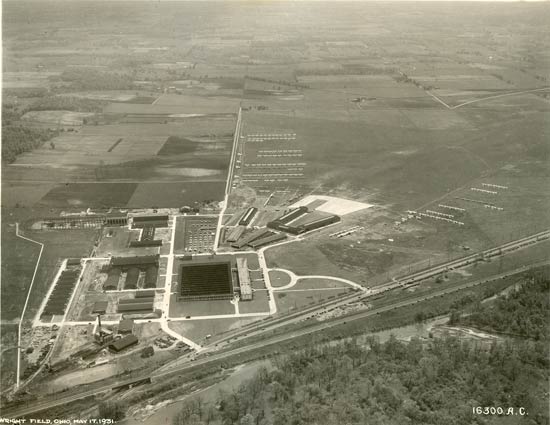 |
Among the pilots of the airplanes above was Ira Eaker, whose passenger Trubee Davison, was Assistant Secretary of War, undoubtedly overseeing these exercises. Another was C.H. Howard, who would later win the Mackay Trophy for the most meritorious flight of 1932, for relief of snow-trapped Navajo Indians. He was a founding member of the Order of Daedalians. And another was William Tunner, later General in command of the Ferrying Division headed by Nancy Harkness Love.
---o0o---
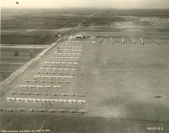
Below, a photograph of the Lansing, IL Ford Airport, taken on May 19, 1931. Two landings were made by Register pilot E.L. Preston from Lansing. The ranks of aircraft suggest an air meet. Military aircraft are lined up at the top of the image, probably not along survey lines (see March Field, above). Does anyone KNOW what the event on May 19, 1931 was all about?
Lansing, IL, Ford Airport, May 19, 1931
 |
---o0o---
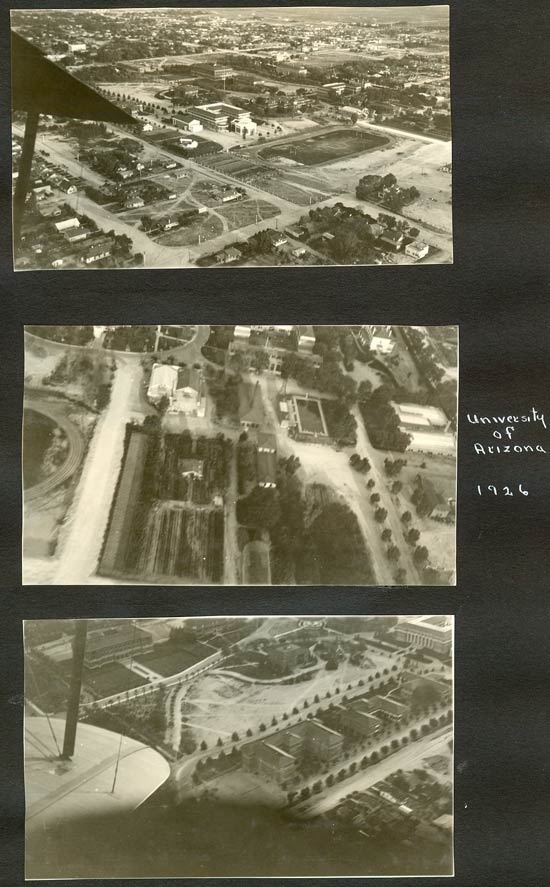
Below, three aerial snapshots of the University of Arizona, Tucson, during 1926. We're not sure who took these images, but it could easily have been Burt Cosgrove, Jr.
University of Arizona Campus, Tucson, AZ, 1926
 |
---o0o---
Below, Charles Lindbergh appears at the dais at Lordsburg, NM, probably the same day or the day after he visited Tucson on September 24, 1927. He was on his U.S. tour following his trans-Atlantic flight the previous May. However, see this image for a possible discrepancy, either of date or event.
Charles Lindbergh, Lordsburg, NM, September, 1927
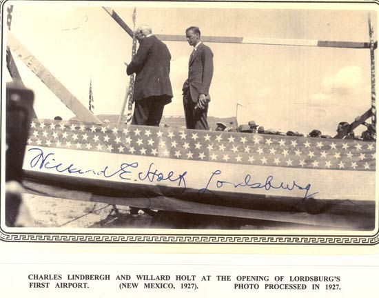 |
Willard Holt was a local Lordsburg judge. Lindbergh was responsible for "opening" or "dedicating" many "new" airfields as he made his way through the 48 states during his tour in the fall of 1927. Many of them, like Davis-Monthan and Lordsburg, had actually been in operation many years. The Lindbergh cachet was very powerful to increasingly air-minded communities across the country.
---o0o---
THIS PAGE UPLOADED: 01/09/07 REVISED: 03/22/08, 07/28/12, 04/19/19
|